Live-data area — real resupply & services data covers this camp. Autonomy still needs your rig.
USFS · Houston National ForestFree to campDraft

Houston National Forest — near Lake Conroe

Houston National Forest · Montgomery County
30.4931° N, 95.6005° W · 203 ft Open in Google Maps ↗
Coordinates are approximate · roads and conditions change · decision support, not navigation.

Everything you need — measured from camp

15 MI30 MI60 MIYOUR CAMPN ↑Water · 20 miWDump · 33 miDChevron · Fuel · 4 miFGrocery · 4 miGWalgreens · Pharmacy · 8 miRxAce Hardware · Hardware · 8 miHMy Transmission Experts · Mechanic · 8 miMMontgomery Washateria · Laundry · 9 miLShower · 28 miShAir-up · 22 miAAction Behavior Centers - ABA Therapy for Autism · Urgent care · 12 mi+Bass Pro Shops · Outfitter · 30 miOUnited States Post Office · Mail · 8 mi@
Straight-line miles · bearings approx · roads run longer

The read: water is a real 20-mi drive, fuel & food sit about 4 mi out, dump cost you a real trip past your 30-mi day.

THE ONE RUN · Houston National Forest — near Lake Conroe
Make it once. Reset the clock.
Your camp
LEAVE EMPTY, COME BACK FULL
1
Fuel — top off the tank
4 mi
2
Grocery — restock food + fridge
4 mi
3
Water — refill jugs + top off
20 mi
4
Dump — empty grey/black tanks
33 mi
Back at camp
CLOCK RESET — GOOD FOR ANOTHER 4–7 DAYS · SAMPLE RIG
Ordered nearest-first by straight-line distance — not a routed loop yet. Drive-time routing is the next refinement.
Open the run in Maps →
Not within 60 mi: Propane. Plan those before you head up.

One dot per need — the nearest of each kind, straight-line from camp; real roads run longer and drive-time is the refinement coming. Places from OpenStreetMap (© OpenStreetMap contributors). Treat all natural water. Open in Google Maps ↗

How we know this

CONFIDENCE · LIKELY
  • World-class recommendation
    GPS and field notes from veteran overlanders Dave vouches for. The source
  • Researched
    Checked and detailed by Dave — five decades in the field. Public data — no copyright on coordinates
  • 0
    Verified on the ground
    No dated visit here yet. Stays Likely until Dave's stood on it — or the crowd confirms
A world-class recommendation — GPS and notes from veteran overlanders Dave vouches for, carried and detailed across his five decades in the field. Coordinates and facts are public. Confidence stays Likely until Dave's been there or the crowd confirms — then real field notes replace this.

From the field

On the shore of Lake Conroe in Houston National Forest. Forested area along dirt road with spanish moss and lush flora. Beautiful setting. Enough room for one or two vehicles. Good cell service. While this is a primitive experience this is a popular spot for local campers and fishermen. Some trash, but not overwhelming. Recommended.

— field note from a world-class overlander Dave vouches for. Verdict: Recommended. Confidence stays Likely until Dave stands on it or the crowd confirms.

At this pin

A dispersed site on national forest — Houston National Forest, Montgomery County. The facts below are structured data from Dave's list; the write-up is being rebuilt from real field notes, so it's held at Likely until it's confirmed on the ground.
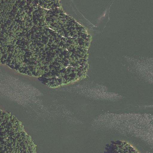
Aerial view of the land around Houston National Forest — near Lake Conroe
Aerial view — USGS NAIP (public-domain, flown in summer), about 660 m across. The pin is the logged GPS, which often sits on the access road you drove in on — the actual dispersed sites are the open clearings on and just off the tracks you can see. Terrain and roads only; not a claim about who owns or manages the exact spot.
Free — no fee
Tent-friendly
Primitive
No 4×4 required
? Cell signal — reports differ list and field disagree · verify it

Stay limits vary by unit — many USFS/BLM areas cap dispersed camping around 14 days, but not all. Confirm the current rule and road status with the managing office before you commit.

Dave was here

Dave was here
Not logged yet. This site is on Dave's list, but there's no dated personal visit for this exact spot. When there is, his notes and photos land here — and confidence moves toward Verified.

What we don't know

  • Road surface & last-mile access
  • How many rigs fit
  • Cell coverage by carrier
  • Seasonal / winter access
  • Current fire restrictions
  • Water access from the pin
  • Shade & wind exposure
  • Noise / neighbors

Screenshot & share

Field card № 851 · Houston National Forest · USFS
Houston National Forest — near Lake Conroe
30.4931°N 95.6005°W · 203 ft · FREE
WATER20 MI
FUEL4 MI
GROCERY4 MI
DUMP33 MI
PROPANENONE / 60
Straight-line miles from camp · OpenStreetMap data · decision support, not navigation
Your stay
~4–7d
Drinking water sends you in first
Solo · ~6–8 gal water/day · streams for washing · sample rig
Data as of Jul 12 2026
American Adventurerdavelalande.com · @davelalande

One camp, one honest read — screenshot it and send it to whoever you’re headed out with.

Worried about sharing a spot like this? Don't be. Getting out here takes effort, guts, and an I wanna be here attitude — the couch-bound 99% adventure through a screen. Why open sharing works →
Keep this camp honest

Been here? Help the next rig.

Confirm it's still good, flag anything that changed, add a photo, or leave your notes. Every check nudges this camp up the confidence ladder — and earns Let 'er Buck Bucks.

Preview — sign-in, moderation, and the Let 'er Buck Bucks ledger get wired next.
No reports yetBeen to Houston National Forest — near Lake Conroe? You'd be the first to verify it.