Live-data area — real resupply & services data covers this camp. Autonomy still needs your rig.
Public landFree to campDraft

Mendocino County

Mendocino County
39.8374° N, 123.8465° W · 52 ft Open in Google Maps ↗
Coordinates are approximate · roads and conditions change · decision support, not navigation.
How we know thisCONFIDENCE · LIKELY
  • World-class recommendation
    GPS and field notes from veteran overlanders Dave vouches for. The source
  • Researched
    Checked and detailed by Dave — five decades in the field. Public data — no copyright on coordinates
  • 0
    Verified on the ground
    No dated visit here yet. Stays Likely until Dave's stood on it — or the crowd confirms
A world-class recommendation — GPS and notes from veteran overlanders Dave vouches for, carried and detailed across his five decades in the field. Coordinates and facts are public. Confidence stays Likely until Dave's been there or the crowd confirms — then real field notes replace this.
From the field
A free primitive campsite among mature redwood trees on the California coast. Picnic tables and fire rings here. Also numerous outhouses. Very rustic. No cell service. This spot is in a shady grove next to a small stream. Four-wheel drive recommended. Enough room for a few vehicles. Numerous other sites in the vicinity but I expect the place to be a crowded party spot in the summer. Recommended.

— field note from a world-class overlander Dave vouches for. Verdict: Recommended. Confidence stays Likely until Dave stands on it or the crowd confirms.

At this pin

A dispersed site on public land, Mendocino County. The facts below are structured data from Dave's list; the write-up is being rebuilt from real field notes, so it's held at Likely until it's confirmed on the ground.
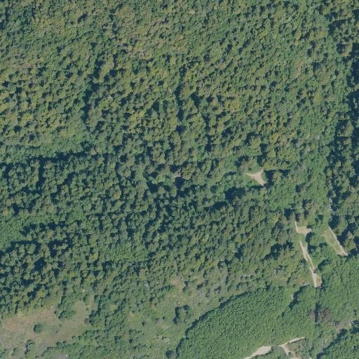
Aerial view of the land around Mendocino County
Aerial view — USGS NAIP (public-domain, flown in summer), about 660 m across. The pin is the logged GPS, which often sits on the access road you drove in on — the actual dispersed sites are the open clearings on and just off the tracks you can see. Terrain and roads only; not a claim about who owns or manages the exact spot.
Free — no fee
Tent-friendly
Fire ring
Vault toilet
Primitive
4×4 recommended
No cell signal

Stay limits vary by unit — many USFS/BLM areas cap dispersed camping around 14 days, but not all. Confirm the current rule and road status with the managing office before you commit.

Dave was here
Dave was here
Not logged yet. This site is on Dave's list, but there's no dated personal visit for this exact spot. When there is, his notes and photos land here — and confidence moves toward Verified.
What we don't know
  • Road surface & last-mile access
  • How many rigs fit
  • Cell coverage by carrier
  • Seasonal / winter access
  • Current fire restrictions
  • Water access from the pin
  • Shade & wind exposure
  • Noise / neighbors
Everything you need — measured from camp
15 mi30 mi60 miYOUR CAMPN ↑Patriot · Fuel · 7 miFLeggett Patriot Gas Station · Fuel · 7 miFPatriot · Fuel · 12 miFRenner Petroleum · Fuel · 12 miFShelter Cove General Store Gas · Fuel · 18 miFLeggett Market · Grocery · 7 miGGrocery · 16 miGShelter Cove RV Park and Campground Groceries · Grocery · 17 miGShelter Cove General Store · Grocery · 18 miGVern's Fairway Mini Mart · Grocery · 18 miGGarberville Pharmacy · Pharmacy · 18 miRxCVS Pharmacy · Pharmacy · 28 miRxRite Aid · Pharmacy · 28 miRxRite Aid · Pharmacy · 41 miRxPalco Pharmacy · Pharmacy · 47 miRxMilt's Saw Shop · Hardware · 18 miHAce Hardware · Hardware · 22 miHRossi Building Materials · Hardware · 27 miHCoast True Value Hardware · Hardware · 27 miHMendo Mill · Hardware · 28 miHLaundry · 16 miLLaundry · 22 miLLucy's · Laundry · 28 miLLaundry · 39 miLLaundry · 40 miLSala's Towing, Auto Repair · Mechanic · 22 miMSchlafer's Garage · Mechanic · 37 miMMechanic · 37 miMMechanic · 40 miMElk Garage · Mechanic · 49 miMDump · 39 miDWater · 19 miWWater · 35 miWWater · 35 miWWater · 35 miWWater · 35 miWAir-up · 30 miAAir-up · 47 miAAir-up · 57 miAAir-up · 59 miAShower · 16 miShShower · 16 miShShower · 16 miShShower 1$/5min · Shower · 24 miShShower · 30 miShSouthern Humboldt Community Clinic · Urgent care · 18 mi+Long Valley Clinic · Urgent care · 22 mi+Laytonville Family Resource Center. Healthy Start · Urgent care · 22 mi+Open Door Community Health Center · Urgent care · 54 mi+Ukiah Valley Rural Health Center · Urgent care · 58 mi+The Outdoor Store · Outfitter · 27 miOThe Fish Peddler · Outfitter · 59 miOLeggett Post Office · Mail · 7 mi@Westport Post Office · Mail · 14 mi@Whitehorn Post Office · Mail · 17 mi@Harris Post Office · Mail · 18 mi@Garberville Post Office · Mail · 18 mi@
Nearest: Water 19 mi · Dump 39 mi · Fuel 7 mi · Grocery 7 mi · Mechanic 22 mi · Pharmacy 18 mi
Not within 60 mi: Propane. Plan those before you head up.
A rough supply run — closest of each, nearest first
  1. 1 Fuel7 mi
  2. 2 Grocery7 mi
  3. 3 Water19 mi
  4. 4 Dump39 mi
Ordered by straight-line distance, not a routed loop — real drive-time is the refinement coming.

Straight-line miles from camp — real roads run longer; drive-time is the refinement coming. Nearest few per category, from OpenStreetMap (© OpenStreetMap contributors). Treat all natural water. Open in Google Maps ↗

Worried about sharing a spot like this? Don't be. Getting out here takes effort, guts, and an I wanna be here attitude — the couch-bound 99% adventure through a screen. Why open sharing works →
Keep this camp honest

Been here? Help the next rig.

Confirm it's still good, flag anything that changed, add a photo, or leave your notes. Every check nudges this camp up the confidence ladder — and earns Let 'er Buck Bucks.

Preview — sign-in, moderation, and the Let 'er Buck Bucks ledger get wired next.
No reports yetBeen to Mendocino County? You'd be the first to verify it.