Beaverhead River Campground (Clark Canyon)
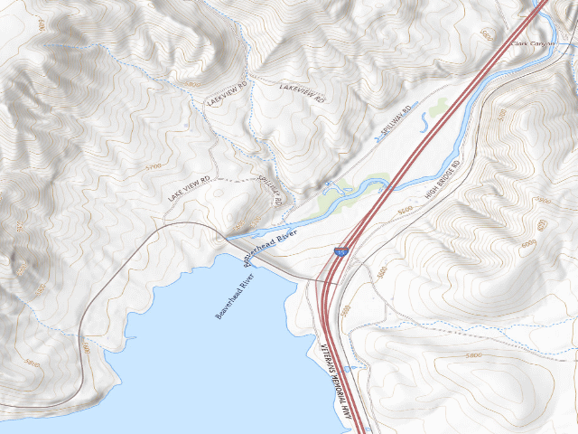
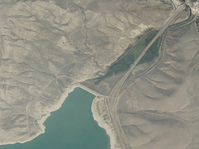
Free primitive camping on Bureau of Reclamation land at Clark Canyon Reservoir, about 20 miles south of Dillon, Montana and right off I-15 -- a genuinely free stop on a stretch where most options charge. Reclamation runs this reservoir itself, and its own records show no camping fee, no entrance fee, no boat-launch fee and no parking fee anywhere on it. The ONE exception on the whole reservoir is the Lewis & Clark Campground/Marina, which has full RV hook-ups and a self-pay fee station -- that is a different campground from this one, and it is the only site Reclamation's own map marks with its "$ Fee Area" symbol. Reclamation describes it as "a frequently used site situated immediately below Clark Canyon Dam ... lush with vegetation and is used by anglers, campers, bird watchers, and other wildlife observers", and a popular launch for floating the Beaverhead River. Picnic tables, camping slabs, and a vault toilet. Access is "from a steep, winding gravel road that begins near the top of Clark Canyon Dam" -- scout it before you take a big rig down. Reclamation lists no water pump here, unlike most of the reservoir campgrounds, so bring your own. Reclamation does not publish a stay limit for these campgrounds anywhere we could find -- you will see "14 nights" repeated on camping websites, but that number does not appear in any Reclamation document, so treat it as unconfirmed and ask the Dillon Field Office. This is primitive camping: expect a vault toilet and, at most sites, a hand pump rather than tap water -- treat or bring drinking water. The reservoir sits at about 5,500 feet and is exposed, so it can be cold and very windy well into the summer. IMPORTANT: Reclamation's facilities record was last updated in 2017 and the brochure is undated, so confirm current fees and rules with the Bureau of Reclamation Dillon Field Office at (406) 683-6472 before you go. We have not visited this site.
Everything you need — measured from Beaverhead River Campground (Clark Canyon) · U.S. Bureau of Reclamation · MT
- DDump1 mi
- WWater10 mi
- FFuel11 mi
- MMechanic18 mi
- LLaundry18 mi
- GGrocery19 mi
- EVEV fast charger21 mi
- @Mail29 mi
- OOutfitter44 mi
- ShShower51 mi
- +Urgent care52 mi
The read: water's a short hop out, fuel & food sit about 11 mi out.
Not within 60 mi: Propane. Plan those before you head up.
One dot per need — the nearest of each kind, straight-line from camp. Places from OpenStreetMap (© OpenStreetMap contributors); the EV fast charger from the US DOE station locator. Open in Google Maps ↗
The site — Beaverhead River Campground (Clark Canyon)
Nearby & resupply — around Beaverhead River Campground (Clark Canyon) · U.S. Bureau of Reclamation · MT (OpenStreetMap)
- Nearest townGrant · ~10.3 mi
- Drinking waternone within 10 mi
- FuelChevron · ~10.9 mi
- Propane / LPGnone within 31 mi
- Dump station~0.8 mi
- GroceriesSafeway · ~18.9 mi
EV charging — from Beaverhead River Campground (Clark Canyon) · U.S. Bureau of Reclamation · MT — nearest public DC fast & Level 2 (US DOE station data)
- Nearest public DC fast charger20.7 mi straight-line S — Dell Mercantile (Dell, MT) · Electrify America · CCS · 4 fast ports listed · listed open, last confirmed by AFDC 2026-09-16 · hours: 24 hours daily · directions
- Public DC fast stations within reach1 within 25 mi · 2 within 50 · 19 within 100 · 54 within 150
- Nearest listing NACS (Tesla)28.7 mi — Lima, MT - Tesla Supercharger, Lima
- Nearest listing CHAdeMO83.2 mi — Island Park City Offices, Island Park
- Nearest public Level 2 (J1772)17.7 mi — UMW #1 STATION 1, Dillon, MT · ChargePoint Network · J1772 · 2 Level 2 ports listed · listed open, last confirmed by AFDC 2026-09-16 · hours: 24 hours daily
- Pricing at the fast chargernot listed
- Power (kW)not listed by AFDC — “DC fast” spans roughly 24 to 350 kW, so ask the network.
- Read this honestlyStraight-line miles, like every distance on this site. Roads run longer than this, and you have to get back. We know where a charger is listed. We don’t know if it works today, how fast it is, or the road miles. Check the network before you commit.
Snapshot 2026-09-16 · AFDC record 121712 · US DOE Alternative Fuels Data Center
Nearby restrooms — around Beaverhead River Campground (Clark Canyon) · U.S. Bureau of Reclamation · MT — pit toilets, restrooms & rest areas (government data)
- Vault / pit toiletClark Canyon Reservoir Recreation Management Area-Spillway Fishing Access Site-Precast Vault Toilet Building · at this camp · BoR
- Vault / pit toiletBuffalo Bridge-Precast Vault Toilet Building · ~0.3 mi E · BoR
- Vault / pit toiletBeaverhead Campground CXT Single Vault Toilet Building · ~0.4 mi S · BoR
- Vault / pit toiletBeaverhead Campground-Precast Vault Toilet Building · ~0.4 mi S · BoR
Open Beaverhead River Campground (Clark Canyon) elsewhere
Other camps near Beaverhead River Campground (Clark Canyon)
If this one is full, gated or washed out.
- Beaverhead Campground (Clark Canyon)~0.5 mi
- Horse Prairie Campground (Clark Canyon)~1.8 mi
- Cameahwait Campground (Clark Canyon)~2.4 mi
- West Cameahwait Campground (Clark Canyon)~2.9 mi
How we know this — Beaverhead River Campground (Clark Canyon)
What we don’t know about Beaverhead River Campground (Clark Canyon)
A land record can put you within a few meters of a spot. It cannot tell you any of this — so check it yourself, and treat anything below as the open question it is.
- Road surface & last-mile access
- How many rigs actually fit
- Cell coverage by carrier
- Seasonal & winter access
- Current fire restrictions
- Whether any water here is drinkable
- Shade & wind exposure
- Noise and who else shows up
- Whether a listed EV charger works today, or the road miles to it