Agency-listedMusselshell CountyFree

Cow Belles Corral Campground (Musselshell County Fairgrounds)

Drive-up · public land · MT · 46.43948, -108.53156
Ask an AI about this campsiteOpens Grok already loaded with this site. It reads the same records this page is built from, and links whatever it tells you.
Ask about this camp →
The land manager lists this site. Someone from the agency inventoried it, so it is a real camp — not a spot we guessed at. What changes is conditions — roads, gates, closures, fire rules. Check those with the unit before you commit to the drive.

There is a donation post at the west entrance. Use it. That is the whole deal here: Musselshell County leaves the gate open at the county fairgrounds on the east edge of Roundup and asks travellers to chip in what the stop was worth, and the Roundup Chamber prints the posted rules plainly -- 'Donations for maintenance are accepted in the donation post on the west entrance. Donations are greatly appreciated.' No fee is charged, but this is a donation site, not a freebie, and a county that trusts you with fourteen days deserves the cash. What you get is a big, flat, unfussy piece of ground: open grass between mature cottonwoods with no marked or numbered sites, so you pick your spot and park -- travellers report room there for the largest rigs, which is rarer than it sounds on this route. The Musselshell River runs alongside and Roundup itself is a couple of minutes west for fuel, groceries and a meal. It is a genuinely good overnight on US-12 between Billings and Lewistown, and one of very few free municipal or county stops left in a state where most towns now price their camping. The rules, straight from the posted list: camping longer than 14 days is prohibited unless you arrange it with Musselshell County; trailers, tents and vehicles cannot be left unattended over 48 hours; quiet hours 10 p.m. to 7 a.m.; and hold it to 15 mph through the grounds. Restrooms are SEASONAL -- roughly mid-to-late May through early-to-mid September, weather depending -- so outside that window assume there is nothing open and be self-contained. We are NOT claiming drinking water: several listings say water is available, but no official source confirms it, so haul your own. One reviewer flags a posted warning about falling branches -- look up before you park under a big cottonwood, especially in wind. TWO THINGS TO KNOW BEFORE YOU TRUST THIS ENTRY. First, this is NOT Roundup City Park -- they are two different places, and the chamber lists them separately, so do not follow a map pin that says 'city park'. Ours points at the 4-H Road access to the county fairgrounds, about three quarters of a mile from the city park. Second, the sources disagree on price: the chamber, The Dyrt and Campendium all describe it as free with a donation post, and one traveller wrote 'the campsite is free, but there is a sign asking for donations, which we did' -- but Good Sam lists it 'From $11 / night' with no detail. We have graded this MED and are telling you about the disagreement rather than hiding it. Arrive with cash either way. The fairgrounds also hosts fairs and rodeos, so expect the place to be busy or closed to campers around events. Call Musselshell County at 406-323-2804 to confirm current rules and whether anything is on before you count on a bed here. Buy your dinner and your fuel in Roundup, pack out everything you brought, and leave it better than you found it. We have not visited this site.
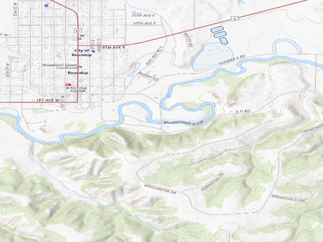
USGS topo — contours & terrain
USGS topographic map of Cow Belles Corral Campground (Musselshell County Fairgrounds)
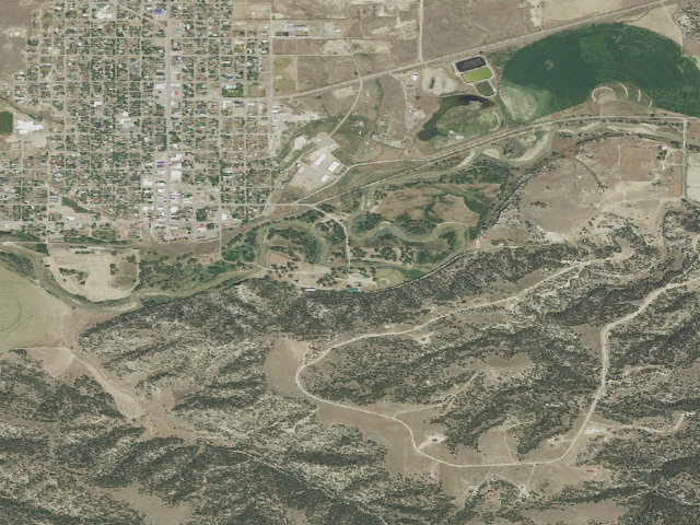
Aerial — USGS / NAIP
Aerial image of Cow Belles Corral Campground (Musselshell County Fairgrounds)
XFacebookReddit
Weather outlook — at Cow Belles Corral Campground (Musselshell County Fairgrounds)
Loading the latest forecast…
Live NWS area forecast (~2.5 km grid, not elevation-corrected). Camp sits at 3,180 ft.
Fire & smoke — around Cow Belles Corral Campground (Musselshell County Fairgrounds)NIFC · AirNow
Checking active fires & air quality…
Active wildfires from NIFC (within ~50 mi); air quality from AirNow. Always confirm current fire restrictions with the managing office before you go.

Everything you need — measured from Cow Belles Corral Campground (Musselshell County Fairgrounds) · public land · MT

15 MI30 MI60 MIYOUR CAMPN ↑Conoco · Fuel · 1 miFMcCleary's · Grocery · 1 miGWalmart Pharmacy · Pharmacy · 42 miRxAce Hardware · Hardware · 42 miHProfab Enterprises · Mechanic · 37 miMLaundry · 39 miLShower · 41 miShBillings Oral Surgery & Dental Implant Center · Urgent care · 42 mi+The Basecamp · Outfitter · 45 miORoundup Post Office · Mail · 1 mi@Billings, MT - North Frontage Road - Tesla Supercharger · EV fast charger · 43 miEV
Straight-line miles · bearings approx · roads run longer
Nearest of each
  • @Mail1 mi
  • FFuel1 mi
  • GGrocery1 mi
  • MMechanic37 mi
  • LLaundry39 mi
  • ShShower41 mi
  • RxPharmacy42 mi
  • +Urgent care42 mi
  • HHardware42 mi
  • EVEV fast charger43 mi
  • OOutfitter45 mi
≤30 mi30–4545+water

The read: fuel & food sit about 1 mi out, the nearest EV fast charger is a 43-mi run (and back).

Not within 60 mi: Water, Dump, Propane. Plan those before you head up.

One dot per need — the nearest of each kind, straight-line from camp. Places from OpenStreetMap (© OpenStreetMap contributors); the EV fast charger from the US DOE station locator. Open in Google Maps ↗

The site — Cow Belles Corral Campground (Musselshell County Fairgrounds)

Access
Drive-up
Land
public land
Elevation
3,180 ft
State
MT
Coordinates
46.43948, -108.53156
Cost
Free

Nearby & resupply — around Cow Belles Corral Campground (Musselshell County Fairgrounds) · public land · MT (OpenStreetMap)

  • Drinking waternone within 10 mi
  • FuelConoco · ~0.8 mi
  • Propane / LPGnone within 31 mi
  • GroceriesMcCleary's · ~0.8 mi

EV charging — from Cow Belles Corral Campground (Musselshell County Fairgrounds) · public land · MT — nearest public DC fast & Level 2 (US DOE station data)

Nearby restrooms — around Cow Belles Corral Campground (Musselshell County Fairgrounds) · public land · MT — pit toilets, restrooms & rest areas (government data)

Open Cow Belles Corral Campground (Musselshell County Fairgrounds) elsewhere

How we know this — Cow Belles Corral Campground (Musselshell County Fairgrounds)

Stay limit
14 nights (Camping longer than 14 days is prohibited unless arrangements have been made with Musselshell County)
Source
Montana municipal park records
Confidence
Likely — The record is good enough to put a pin on, but thin in places. Treat the details as a starting point, not gospel.
How it was placed
Source (FREE/DONATION -- the most authoritative source available, publishing the operator's POSTED site rules): ROUNDUP CHAMBER OF COMMERCE, roundupchamber.org/area-attractions (read 2026-07-28), verbatim -- 'Cow Belles Campground is used for picnicing and overnight camping.'; 'Donations for maintenance are accepted in the donation post on the west entrance. Donations are greatly appreciated.'; 'Camping longer than 14 days is prohibited unless arrangements have been made with Musselshell County.'; 'Camp Site Trailers, Tents and Vehicles cannot be left unattended for over 48 hours.'; 'Quiet hours are enforced between 10:00 p.m. and 7:00 a.m.'; 'Speed limit through Cow Belles is not to exceed 15 mph.'; 'Restrooms are only open seasonaly during warm weather. (Usually mid to late May through the 1st to mid September depending on weather patterns.)' CORROBORATION (independent, first-hand): The Dyrt review -- 'The campsite is free, but there is a sign asking for donations, which we did.' plus a second entry typing the site as 'Donation camping'; Campendium likewise free-with-donation-sign. CONFLICT DISCLOSED, NOT RESOLVED AWAY: GOOD SAM lists 'From $11 / night' with no citation and no rate detail. Ingested fee=0 confidence='med' with the conflict written into the field_note, per the previous MT fire's own Lesson 2 ('an aggregator saying FEE is not a price either' -- the Sanford Park call), the symmetric twin of NE Lesson 1 ('silence is not free'). NOT 'high' because roundupchamber.org is a chamber, not a .gov, and Musselshell County's own site (musselshellcounty.org) 403s every method tried. OPERATOR: MUSSELSHELL COUNTY -- established by the chamber's own '...arrangements have been made with Musselshell County' line; this is COUNTY land at the MUSSELSHELL COUNTY FAIRGROUNDS, NOT a city park. The previous fire's 'Roundup city park' framing pointed at the wrong owner, which is why the name would not resolve. COORDINATE -- THE HOLD THE 2026-07-20 FIRE COULD NOT SOLVE, SOLVED BY GEOCODING THE OPERATOR'S FACILITY INSTEAD OF THE SITE NAME: 'Cow Belles' is absent from OSM, does not geocode in Nominatim, and the chamber publishes no address -- three dead ends on the NAME. The fairgrounds, however, has an ordinary published address, 35 4-H Rd, Roundup MT 59072 (corroborated by MSU Extension's Musselshell-Golden Valley fairgrounds listing and by Waze), which geocodes first try. THREE fully independent listings then agree on the spot: Campendium 46.439964,-108.531549; The Dyrt 46.440278,-108.531688 (120 ft away); Good Sam 46.439104,-108.531712 (316 ft away) -- total spread under 430 ft, centroid 46.439782,-108.531650. BANKED OSM node/44725495 (46.4394832,-108.5315596), a SURVEYED node on 4-H Road (way/5767452, 8 nodes, full geometry via api.openstreetmap.org) -- the very street in the county's own address -- lying 111 ft from that centroid (175 ft Campendium / 144 ft Good Sam / 292 ft The Dyrt). Nominatim's geocode of the address itself lands 934 ft off, on the road centreline, and was NOT used. HONEST LIMIT: OSM still has no camp object here, so the pin is the 4-H Road access alongside the fairgrounds camping area, not a surveyed campsite; The Dyrt's written directions corroborate the approach ('From Jct of Main St & E Second, E 0.5 mi on E Second/at Fairground (L)'). NOT THE CITY PARK: the chamber lists Cow Belles and Roundup City Park as SEPARATE facilities and the banked pin is 0.74 mi from OSM's Roundup City Park polygon (way/333878405), outside the 0.5 mi dedup radius. Nearest existing MT lead of any source: 35.5 mi (checked against all 4,674). GUARDRAILS: camping is expressly ALLOWED (the chamber quotes the posted rules) and there is NO entry fee, day-use fee, permit or access pass on any source. land_manager='Musselshell County'; dispersed=0; camp_type NULL; water NULL -- listings report water available but NO official source states potable water, so it is NOT claimed. Restrooms seasonal per the chamber. Ingest 2026-07-28. --- NIGHTSHIFT REVIEW 2026-08-21 (fire 1220, leftover backlog) --- HOLDS UP. Re-read roundupchamber.org/area-attractions this fire; the operator's posted rules are still published verbatim as recorded: 'Cow Belles Campground is used for picnicing and overnight camping.', 'Donations for maintenance are accepted in the donation post on the west entrance. Donations are greatly appreciated.', 'Camping longer than 14 days is prohibited unless arrangements have been made with Musselshell County.', 'Quiet hours are enforced between 10:00 p.m. and 7:00 a.m.', and 'Restrooms are only open seasonaly during warm weather. (Usually mid to late May through the 1st to mid September depending on weather patterns.)' Camping is expressly allowed, the ask is a donation post and not a gate, and the Musselshell County ownership is still established by the chamber's own 'arrangements have been made with Musselshell County' line. OSM node 44725495 re-fetched live this fire and still present (v3) at this exact coordinate. The Good Sam 'From $11 / night' conflict recorded at ingest is unresolved and stays disclosed rather than argued away. Water still NOT claimed as potable -- no official source states it. APPROVED at medium: a chamber page, not a .gov.
EV chargers
US DOE Alternative Fuels Data Center station locator, snapshot 2026-09-16. Straight-line miles to the nearest public, open, unrestricted station; restricted and planned units are shown but never counted.
Field check
On the agency's books. The land manager inventoried this site, so its existence is not in question — current conditions are. Nobody from here has camped it recently.

What we don’t know about Cow Belles Corral Campground (Musselshell County Fairgrounds)

A land record can put you within a few meters of a spot. It cannot tell you any of this — so check it yourself, and treat anything below as the open question it is.

Before you go — Cow Belles Corral Campground (Musselshell County Fairgrounds)

Been here? Tell us what changed. This page is built from public records, so the fastest way it gets better is somebody who has actually pulled in. Road washed out, site gone, gate locked, or it is exactly as described — all of it useful. Send a report →