Agency-listedNPSFee
Fifteenmile Creek Campground (C&O Canal NHP, towpath mile 140.0)
Drive-up · National Park Service · MD · 39.62473, -78.38484
Ask an AI about this campsiteOpens Grok already loaded with this site. It reads the same records this page is built from, and links whatever it tells you.
Ask about this camp →National Park Service lists this site. Someone from the agency inventoried it, so it is a real camp — not a spot we guessed at. What changes is conditions — roads, gates, closures, fire rules. Check those with the unit before you commit to the drive.
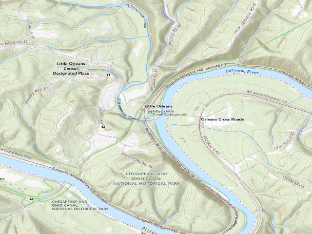
USGS topo — contours & terrain
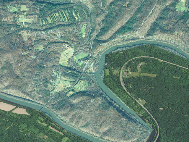
Aerial — USGS / NAIP
Weather outlook — at Fifteenmile Creek Campground (C&O Canal NHP, towpath mile 140.0)
Loading the latest forecast…
Live NWS area forecast (~2.5 km grid, not elevation-corrected). Camp sits at 434 ft.
Fire & smoke — around Fifteenmile Creek Campground (C&O Canal NHP, towpath mile 140.0)NIFC · AirNow
Checking active fires & air quality…
Active wildfires from NIFC (within ~50 mi); air quality from AirNow. Always confirm current fire restrictions with the managing office before you go.
Everything you need — measured from Fifteenmile Creek Campground (C&O Canal NHP, towpath mile 140.0) · National Park Service · MD
▲ your camp. Rings are 15, 30 and 60 straight-line miles; bearings are approximate and roads run longer.
Nearest of each
- DDump4 mi
- ShShower4 mi
- GGrocery5 mi
- @Mail5 mi
- FFuel6 mi
- MMechanic8 mi
- LLaundry8 mi
- RxPharmacy8 mi
- HHardware8 mi
- WWater8 mi
- PPropane8 mi
- OOutfitter8 mi
- +Urgent care13 mi
- AAir-up24 mi
≤30 mi30–4545+water
The read: water's a short hop out, fuel & food sit about 5 mi out.
One dot per need — the nearest of each kind, straight-line from camp. Places from OpenStreetMap (© OpenStreetMap contributors); the EV fast charger from the US DOE station locator. Open in Google Maps ↗
The site — Fifteenmile Creek Campground (C&O Canal NHP, towpath mile 140.0)
Access
Drive-up
Land
National Park Service
Elevation
434 ft
State
MD
Coordinates
39.62473, -78.38484
Cost
Fee · NPS CHOH camping page (nps.gov/choh/planyourvisit/camping.htm): '$20 per site per night, pass holders may be entitled to additional discounts.'
Nearby & resupply — around Fifteenmile Creek Campground (C&O Canal NHP, towpath mile 140.0) · National Park Service · MD (OpenStreetMap)
- Water featureFifteenmile Creek (river) · mapped within 1.6 mi
- Nearest townLittle Orleans · ~0.1 mi
- Drinking waterDrinking water · ~8.3 mi
- FuelFuel · ~5.6 mi
- Propane / LPGBlue Flame Inc. · ~7.8 mi
- Dump station~4.1 mi
- GroceriesPaw Paw Country Store · ~7.3 mi
- PharmacyWalgreens · ~7.9 mi
- Hospital / clinicWar Memorial Hospital · ~9.9 mi
- HardwareAce Hardware · ~8.0 mi
Nearby restrooms — around Fifteenmile Creek Campground (C&O Canal NHP, towpath mile 140.0) · National Park Service · MD — pit toilets, restrooms & rest areas (government data)
- RestroomFifteen Mile Toilet · at this camp · NPS
- RestroomIndigo Neck Toilet · ~1.2 mi E · NPS
- RestroomDevils Alley Toilet · ~1.5 mi W · NPS
- RestroomStickpile Toilet · ~2.9 mi S · NPS
Coming out here — Fifteenmile Creek Campground (C&O Canal NHP, towpath mile 140.0) · National Park Service · MD
- Surface water mapped nearby: Fifteenmile Creek (river). That is wash water at best, and nobody has checked it for you — a creek can be dry and a tank can be mud. Filter or boil anything you drink.
- Power: Dave carries his own — batteries or solar. A generator will run your rig and it is also the thing everybody camped near you can hear.
- Getting online: Dave recommends Starlink. He has had it since SpaceX introduced it, used it for four years living on the road, and it delivers as promised — several hundred nights out, and he can count on one hand the places he could not connect. The cable on his unit runs 150 feet, which is usually all it takes to find enough sky. Starlink → Referral link — Starlink pays Dave $100 in cash if you sign up through it, and that money funds this site and the next trip. It costs you nothing and does not change the recommendation.
Open Fifteenmile Creek Campground (C&O Canal NHP, towpath mile 140.0) elsewhere
Other camps near Fifteenmile Creek Campground (C&O Canal NHP, towpath mile 140.0)
If this one is full, gated or washed out.
- Green Ridge State Forest primitive campsite 83~2.1 mi · fee
- Green Ridge State Forest primitive campsite 87~3.0 mi · fee
- Green Ridge State Forest primitive campsite 70~3.1 mi · fee
- Green Ridge State Forest primitive campsite 88~3.2 mi · fee
How we know this — Fifteenmile Creek Campground (C&O Canal NHP, towpath mile 140.0)
Stay limit
14 nights (14 days between May 1 and October 1; 30 days total per calendar year)
Area rules
RV's must drive to the campground via High Germany Rd. While access can be had via Orleans Rd, High Germany Rd. must be taken with a RV or larger vehicle as there is a tunnel on Orleans Rd.
Source
public land records
Confidence
Researched — The record is detailed and internally consistent, and the coordinates land where the managing agency says this site is.
How it was placed
NPS C&O Canal NHP 'Reservable Campgrounds' page (nps.gov/choh/planyourvisit/reservable-campgrounds.htm, read 2026-09-27) and camping page (.../camping.htm): drive-in campgrounds are 'By reservation only' via recreation.gov; '$20 per site per night, pass holders may be entitled to additional discounts. Limit eight people per site.' 'Stay is limited to 14 days between May 1 and October 1. Stay is limited to a total of 30 days for the entire calendar year. No RV Hookups. Trailer length may not exceed 20 feet.' 'All sites have: chemical toilet, picnic table, firepit, and well water.' Water: NPS says drive-in well water 'is potable and treated with iodine - do NOT drink if you have any iodine allergies or if you are on medication for an overactive thyroid', advises boiling or treating it as a flood-zone precaution, and says it is 'turned off from mid-November to mid-April each year.' 'Antietam Creek and Paw Paw have adjacent parking, but visitors cannot park at the actual campsite. Visitors may not park and sleep in recreational vehicles in these parking areas.' Coordinate = recreation.gov facility 252968 lat/long (public search API, read 2026-09-27). VERIFIED by projecting it onto the OSM C&O towpath relation 1392951 (stitched 180.08 mi + the 4.42 mi DC offset calibrated in the 2026-08-13 fire): it lands at towpath mile 140.91, 396 ft off the towpath centreline. NPS mileposts: reservable-campgrounds page gives mile 140.0; the NPS Park Planner PDF (nps.gov/choh/planyourvisit/upload/Park_Planner_web.pdf) 'Recreational Guide by Milepost' gives 140.9. County per FCC Census Block API: Allegany County, MD, matching the county NPS lists. Nearest town: Little Orleans ~0.1 mi. 'Nearest town' is straight-line distance to the nearest OSM place=city/town/village, NOT a driving distance; in the Potomac valley the nearest named place is often across the river in WV or PA. Ingest 2026-09-27. | REVIEW 2026-09-27 (nightshift-verified, fire 2660): Both NPS pages re-read today (camping.htm and reservable-campgrounds.htm, both footer 'Last updated: November 19, 2025'): 'By reservation only', the 14-day May 1-Oct 1 / 30-day-a-year stay limits, 'No RV Hookups', 'Trailer length may not exceed 20 feet', 'All sites have: chemical toilet, picnic table, firepit, and well water', the iodine-treated potable well water with the flood-zone boil advice and the mid-Nov to mid-Apr shutoff, and 'Limit eight people per site' are all present verbatim; the five campgrounds, their mileposts and counties are unchanged. CORRECTION of attribution only: '$20 per site per night, pass holders may be entitled to additional discounts' is on camping.htm, NOT on reservable-campgrounds.htm as fee_evidence said -- fee_evidence re-pointed. The five rows pair one-to-one with the five NPS campground POIs by name; no POI is claimed twice. recreation.gov facility 252968 'Fifteen Mile Creek Campsite' still gives exactly this lat/long. Active notice adds: 'RV's must drive to the campground via High Germany Rd. ... High Germany Rd. must be taken with a RV or larger vehicle as there is a tunnel on Orleans Rd.' (put in rules_json.area_rules). NPS Public POIs: 'Fifteen Mile Creek Campground' (Campground) is the nearest POI, 90 m. Duplicate check on COORDINATES: nearest approved/published camp is row 16945 'Indigo Neck hiker-biker campsite (C&O Canal towpath mile 139' at 2007 m -- not a duplicate. DECISION: approved. | REVIEW 2026-09-27 addendum (fire 2660): tag 'reservation-required' added -- NPS says 'By reservation only' and build_map.py prints 'Reservation required' only for that tag, not for the existing 'reservation-only'.
Field check
On the agency's books. The land manager inventoried this site, so its existence is not in question — current conditions are. Nobody from here has camped it recently.
What we don’t know about Fifteenmile Creek Campground (C&O Canal NHP, towpath mile 140.0)
A land record can put you within a few meters of a spot. It cannot tell you any of this — so check it yourself, and treat anything below as the open question it is.
- Road surface & last-mile access
- How many rigs actually fit
- Cell coverage by carrier
- Seasonal & winter access
- Current fire restrictions
- Whether any water here is drinkable
- Shade & wind exposure
- Noise and who else shows up
- Whether a listed EV charger works today, or the road miles to it
Before you go — Fifteenmile Creek Campground (C&O Canal NHP, towpath mile 140.0)
Finding water out here →Fire rules & restrictions →Off-grid communication →First-night troubleshooting →All field notes →