Agency-listedMichigan DNRFee
High Bridge State Forest Campground
Drive-up · public land · MI · 46.60761, -85.60126
Ask an AI about this campsiteOpens Grok already loaded with this site. It reads the same records this page is built from, and links whatever it tells you.
Ask about this camp →The land manager lists this site. Someone from the agency inventoried it, so it is a real camp — not a spot we guessed at. What changes is conditions — roads, gates, closures, fire rules. Check those with the unit before you commit to the drive.
$20, first-come, rustic. Recreation Passport required for vehicle entry. Pay at the kiosk.
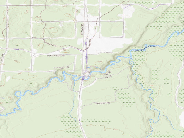
USGS topo — contours & terrain
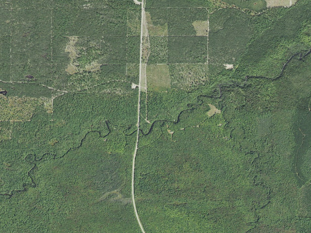
Aerial — USGS / NAIP
Weather outlook — at High Bridge State Forest Campground
Loading the latest forecast…
Live NWS area forecast (~2.5 km grid, not elevation-corrected). Camp sits at 714 ft.
Fire & smoke — around High Bridge State Forest CampgroundNIFC · AirNow
Checking active fires & air quality…
Active wildfires from NIFC (within ~50 mi); air quality from AirNow. Always confirm current fire restrictions with the managing office before you go.
Everything you need — measured from High Bridge State Forest Campground · public land · MI
Straight-line miles · bearings approx · roads run longer
Nearest of each
- FFuel2 mi
- GGrocery2 mi
- DDump5 mi
- @Mail18 mi
- +Urgent care18 mi
- ShShower19 mi
- HHardware19 mi
- WWater20 mi
- EVEV fast charger24 mi
- MMechanic29 mi
- LLaundry54 mi
- RxPharmacy54 mi
≤30 mi30–4545+water
The read: water's a short hop out, fuel & food sit about 2 mi out.
Not within 60 mi: Propane. Plan those before you head up.
One dot per need — the nearest of each kind, straight-line from camp. Places from OpenStreetMap (© OpenStreetMap contributors); the EV fast charger from the US DOE station locator. Open in Google Maps ↗
The site — High Bridge State Forest Campground
Access
Drive-up
Land
public land
Elevation
714 ft
State
MI
Coordinates
46.60761, -85.60126
Cost
Fee
Nearby & resupply — around High Bridge State Forest Campground · public land · MI (OpenStreetMap)
- Nearest townGrand Marais · ~17.9 mi
- Drinking waternone within 10 mi
- FuelFuel · ~2.5 mi
- Propane / LPGnone within 31 mi
- Dump station~4.9 mi
- GroceriesPine Stump Junction · ~2.5 mi
- Hospital / clinicBurt Township Medical Center · ~18.5 mi
- HardwareNewberry Ace Hardware · ~19.2 mi
EV charging — from High Bridge State Forest Campground · public land · MI — nearest public DC fast & Level 2 (US DOE station data)
- Nearest public DC fast charger24.4 mi straight-line SW — Andys Seney Bar (at a public site) · RED_E · CCS, NACS (Tesla) · 2 fast ports listed · listed open, last confirmed by AFDC 2026-09-16 · hours: not listed · directions
- Public DC fast stations within reach1 within 25 mi · 1 within 50 · 25 within 100 · 80 within 150
- Nearest listing CHAdeMO51.8 mi — Munising City Hall, Munising
- Nearest public Level 2 (J1772)21.5 mi — Quality Inn and Suites, Newberry, MI (at a hotel) · Non-Networked · J1772 · 2 Level 2 ports listed · listed open, last confirmed by AFDC 2025-11-13 · hours: 24 hours daily
- Pricing at the fast chargernot listed
- Power (kW)not listed by AFDC — “DC fast” spans roughly 24 to 350 kW, so ask the network.
- Read this honestlyStraight-line miles, like every distance on this site. Roads run longer than this, and you have to get back. We know where a charger is listed. We don’t know if it works today, how fast it is, or the road miles. Check the network before you commit.
Snapshot 2026-09-16 · AFDC record 464964 · US DOE Alternative Fuels Data Center
Nearby restrooms — around High Bridge State Forest Campground · public land · MI — pit toilets, restrooms & rest areas (government data)
- RestroomSF Sable Falls Comfort Station · ~20.0 mi W · NPS
- RestroomGS Grand Sable Visitor Center Vault Toilet Bldg. #55 · ~20.2 mi W · NPS
- RestroomGS Grand Sable Visitor Center Bldg. #5 · ~20.2 mi W · NPS
- RestroomGS Grand Sable Boat Launch Vault Toilet · ~20.5 mi W · NPS
Open High Bridge State Forest Campground elsewhere
Other camps near High Bridge State Forest Campground
If this one is full, gated or washed out.
- Headquarters Lake State Forest Campground and Trail Camp~1.2 mi · fee
- Perch Lake State Forest Campground~1.6 mi · fee
- Pretty Lake State Forest Campground~2.7 mi · fee
- Holland Lake State Forest Campground~2.7 mi · fee
How we know this — High Bridge State Forest Campground
Stay limit
15 nights (15-day maximum)
Permit
Please note, vehicle entry into all state parks, recreation areas and state forest campgrounds require a Recreation Passport.
Area rules
There is one camping unit and six people allowed per site. A responsible adult (18 years or older) must register and sleep at the campsite each night. Campsites are for overnight stays. If a campsite is left empty for more than 24 hours, it's considered abandoned. The use of fuel-powered generators is not allowed during established quiet hours (10 p.m. to 8 a.m.).
Source
public land records
Confidence
Agency-confirmed — The managing agency's own record names this as a campsite and puts it at these coordinates. About as good as it gets short of standing here.
How it was placed
MICHIGAN STATE FOREST CAMPGROUND. Michigan DNR, https://www.michigan.gov/dnr/things-to-do/camping-and-lodging/state-forest-campgrounds read 2026-08-17: 'If you're looking for a more rustic camping experience, check out our 140-plus state forest campgrounds located throughout Michigan's Upper and northern Lower Peninsulas. Each campground is located on a river or lake... Most state forest campgrounds are first-come, first-served. A select few can be reserved ahead of time at MiDNRReservations.com. Please note, vehicle entry into all state parks, recreation areas and state forest campgrounds require a Recreation Passport.' The same page lists what every one of these campgrounds has -- vault toilets, a hand-pump well, parking for two vehicles per site, a picnic table and a fire pit -- and what none of them has: 'Electric hookups: There are no electrical units in campsites or common electrical sources' and no wi-fi. THIS CAMPGROUND, per the DNR amenity table https://www.michigan.gov/dnr/things-to-do/camping-and-lodging/state-forest-campgrounds/amenity-table read 2026-08-17: listed as 'High Bridge State Forest Campground' in Luce County. Type: rustic. Nightly fee: $20. Campsites: 6. Managed by: Muskallonge Lake SP (906-658-3338). Seasonal closure: the table records 'open all year' -- but read that as the DNR not closing the gate, not as a promise the access road is plowed. Reservations: not reservable -- first-come, first-served. DNR DESCRIPTION (from the agency's own recreation-search record): Situated on the banks of the Two Hearted River, this rustic campground offers great opportunities for paddlesports and fishing. It is located in Luce County, 22 miles north of Newberry. This campground is managed by Muskallonge Lake State Park . DNR LONGER DESCRIPTION: This rustic campground is located on the Two Hearted River and is a popular destination for anglers. Accessing the river directly from this campground is challenging due to steep banks and swift moving water. Anglers and paddlers should be cautious while entering the river. The Pine Ridge trail and the Two Heart trail are accessible from the campground for ORVing. There are six sites for tent and small trailer use. Camping is limited to a 15-day maximum stay. Amenities include vault toilets and potable water from a hand-pump well. The campground is located 22 miles north of Newberry via M-123 and County Road 407. Sites available on a first-come, first-serve basis. No reservations. View Campground closing and opening dates . NEAREST TOWN: Newberry, about 22.0 miles, per the DNR description quoted above. STAY LIMIT AND HOUSE RULES, Michigan DNR FAQ 'Camping in a state forest', https://www.michigan.gov/dnr/faqs/state-parks-and-camping/camping-in-a-state-forest read 2026-08-17: 'There is one camping unit and six people allowed per site. A responsible adult (18 years or older) must register and sleep at the campsite each night. Campsites are for overnight stays. If a campsite is left empty for more than 24 hours, it's considered abandoned. To give everyone a chance to enjoy state forest campgrounds during peak season (May 15-Sept. 15), the maximum stay is 15 nights. Once you hit that limit, you'll need to take a 5-night break before returning to the same park.' Check-in is 3 p.m., checkout 1 p.m. 'Camping fees and registration procedures are posted at the information kiosk at each campground.' Quiet hours 10 p.m.-8 a.m., and fuel-powered generators are not allowed during them. 'Paying and holding' a site before you arrive is prohibited. COORDINATE PROVENANCE: Michigan DNR's own ArcGIS feature service https://services3.arcgis.com/Jdnp1TjADvSDxMAX/ArcGIS/rest/services/State_Forest_Campground_Recreation_Search_Points/FeatureServer/0 (layer RecSearchPts_Join_SFCG, 143 points), pulled 2026-08-17. This is an agency coordinate, not OpenStreetMap and not a field visit. Attributes (fee, season, manager, campsite count) come from the DNR amenity table https://www.michigan.gov/dnr/things-to-do/camping-and-lodging/state-forest-campgrounds/amenity-table read the same day. The two datasets were joined on county + name + campsite count; see the header of _mi_f920_insert.py for the method and its failure modes. NOT CHECKED: I did not verify any site-specific fire restriction or burn ban for this campground. Michigan issues burn permits and restrictions seasonally through a separate DNR system (Michigan.gov 'Permission to burn'); check it before publishing any fire-related claim about this site. | auto:agency-trust 2026-08-18: state agency GIS record with a source URL and coordinates, confidence not low. Fee value is the agency's own, not field-checked. Not field-verified -- confirm access, road conditions and fire rules before you go.
EV chargers
US DOE Alternative Fuels Data Center station locator, snapshot 2026-09-16. Straight-line miles to the nearest public, open, unrestricted station; restricted and planned units are shown but never counted.
Field check
On the agency's books. The land manager inventoried this site, so its existence is not in question — current conditions are. Nobody from here has camped it recently.
What we don’t know about High Bridge State Forest Campground
A land record can put you within a few meters of a spot. It cannot tell you any of this — so check it yourself, and treat anything below as the open question it is.
- Road surface & last-mile access
- How many rigs actually fit
- Cell coverage by carrier
- Seasonal & winter access
- Current fire restrictions
- Whether any water here is drinkable
- Shade & wind exposure
- Noise and who else shows up
- Whether a listed EV charger works today, or the road miles to it
Before you go — High Bridge State Forest Campground
Been here? Tell us what changed. This page is built from public records, so the fastest way it gets better is somebody who has actually pulled in. Road washed out, site gone, gate locked, or it is exactly as described — all of it useful. Send a report →