Hollywood Road Campsite 1 (Grass River Wild Forest)
FREE primitive camping in Grass River Wild Forest, part of New York's Adirondack Forest Preserve (DEC Region 6, the Tooley Pond Road waterfall country of St. Lawrence County in the northwestern Adirondacks). This is a DEC-designated primitive tent site ('Hollywood Road Campsite 1'), and New York provides it at NO CHARGE: the DEC page lists the fee as 'Free'. NEAR-DRIVE-UP: this site is about 161 feet from a woods track off Hollywood Road (~160 ft). Note: in the Leonard Pond parcel about 160 feet off a woods track that OSM tags a track rather than a public highway; confirm the road is open to public motor vehicles before relying on driving in. Not a waterside site (the nearest mapped river is about 0.35 mi off). This is interior Adirondack Forest Preserve, not a developed campground -- there is no campground office, fee booth, hookups, showers or potable water; do not confuse it with a developed fee campground such as Higley Flow State Park to the north. SEASON / CLOSURE: DEC lists these Wild Forest parcels as open YEAR-ROUND. The combined Grass River Complex page also notes an annual Oct 1 - Dec 15 closure -- but that closure applies to the separate Grass River CONSERVATION EASEMENT TRACT, NOT to this Wild Forest site, so it does not close this spot. Even so, these are unplowed backcountry trailheads and woods roads: expect snow-covered or impassable access in winter and early spring, and confirm current road/trail status with the Potsdam office before a late-fall, winter or early-spring trip. RULES: this is a designated, first-come first-served free site -- no reservation and no fee. Look for the yellow 'Camp Here' disc that marks each designated site. Standard Adirondack Forest Preserve rules apply: camp only at the designated site, keep 150 feet from water/trails/roads unless the site itself is closer, and a free Forest Ranger permit is required only if you stay more than 3 nights or camp with a group of 10 or more (arrange it through the DEC Region 6 Potsdam Office at (315) 265-3090 (Forest Rangers via 911 or DEC dispatch)). DEC prints no other night limit for these sites, so plan around that statewide 3-night default and confirm on site. This is a primitive site: expect at most a fire ring -- no hookups, no showers and no potable water, so bring water or treat what you take from the river or pond. Pack out all trash, follow Leave No Trace and the DEC fire rules, and store food from bears (this is black-bear country). Confirm current rules and this site's status on the DEC page (dec.ny.gov/places/grass-river-complex) or with the Potsdam office ((315) 265-3090) before you go; we have not visited.
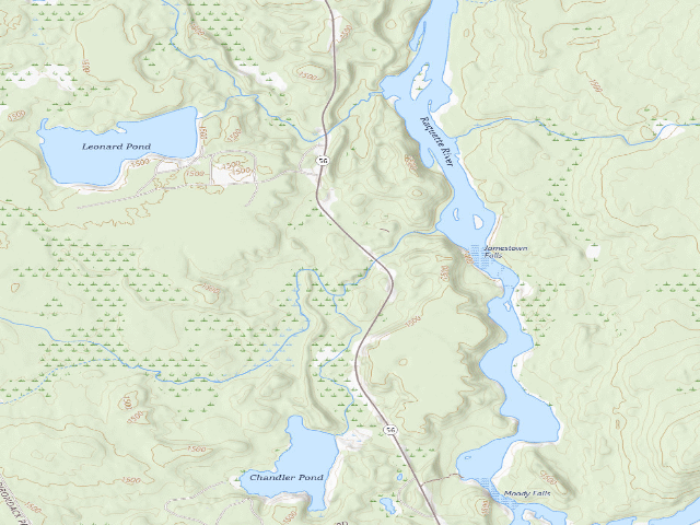
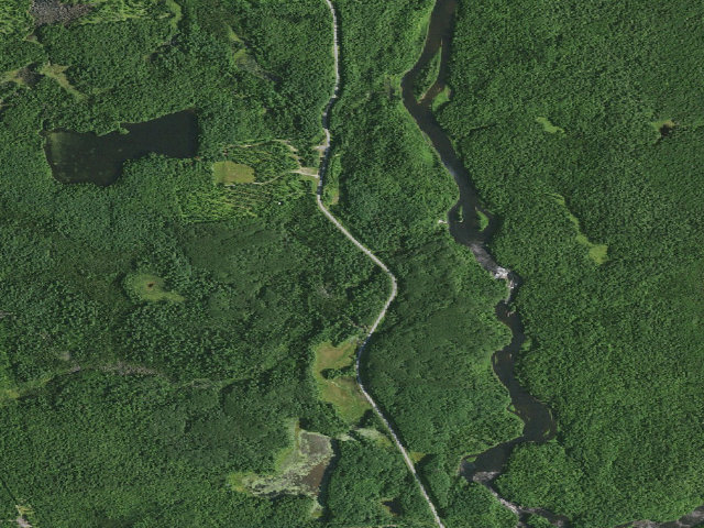
Everything you need — measured from Hollywood Road Campsite 1 (Grass River Wild Forest) · New York State Dept. of Environmental Conservation · NY
- +Urgent care6 mi
- MMechanic12 mi
- FFuel13 mi
- GGrocery13 mi
- RxPharmacy14 mi
- HHardware15 mi
- @Mail15 mi
- OOutfitter15 mi
- DDump15 mi
- ShShower15 mi
- WWater16 mi
- EVEV fast charger27 mi
- LLaundry27 mi
The read: water's a short hop out, fuel & food sit about 13 mi out.
Not within 60 mi: Propane. Plan those before you head up.
One dot per need — the nearest of each kind, straight-line from camp. Places from OpenStreetMap (© OpenStreetMap contributors); the EV fast charger from the US DOE station locator. Open in Google Maps ↗
The site — Hollywood Road Campsite 1 (Grass River Wild Forest)
Nearby & resupply — around Hollywood Road Campsite 1 (Grass River Wild Forest) · New York State Dept. of Environmental Conservation · NY (OpenStreetMap)
- Water featureLeonard Pond (water) · nearby
- Nearest townSevey · ~1.9 mi
- Drinking waternone within 10 mi
- FuelMobil · ~13.4 mi
- Propane / LPGnone within 31 mi
- Dump station~15.4 mi
- GroceriesSave-A-Lot · ~14.4 mi
- PharmacyKinney Drugs · ~14.3 mi
- Hospital / clinicCamp Massawepie Health Lodge · ~5.8 mi
- HardwareEvans and Whites · ~27.0 mi
EV charging — from Hollywood Road Campsite 1 (Grass River Wild Forest) · New York State Dept. of Environmental Conservation · NY — nearest public DC fast & Level 2 (US DOE station data)
- Nearest public DC fast charger27.0 mi straight-line NW — EVolve NY Potsdam · Electrify America · CHAdeMO, CCS · 4 fast ports listed · listed open, last confirmed by AFDC 2026-09-16 · hours: 24 hours daily · directions
- Public DC fast stations within reachnone within 25 mi · 16 within 50 · 138 within 100 · 359 within 150
- Nearest listing NACS (Tesla)27.0 mi — Potsdam, NY - Tesla Supercharger, Potsdam
- Nearest public Level 2 (J1772)16.5 mi — Otto's Abode, Wanakena, NY (at a parking lot) · Non-Networked · J1772 · 1 Level 2 port listed · listed open, last confirmed by AFDC 2024-03-14 · hours: 24 hours daily
- Also listed, not counted aboveNACS-only Level 2 — Faust Motel - Tesla Destination, Tupper Lake, 13.0 mi · NACS (Tesla) · hours: 24 hours daily. Open to Teslas only. · AFDC lists it “Free”
- Pricing at the fast chargernot listed
- Power (kW)not listed by AFDC — “DC fast” spans roughly 24 to 350 kW, so ask the network.
- Read this honestlyStraight-line miles, like every distance on this site. Roads run longer than this, and you have to get back. We know where a charger is listed. We don’t know if it works today, how fast it is, or the road miles. Check the network before you commit.
Snapshot 2026-09-16 · AFDC record 279325 · US DOE Alternative Fuels Data Center
Nearby restrooms — around Hollywood Road Campsite 1 (Grass River Wild Forest) · New York State Dept. of Environmental Conservation · NY — pit toilets, restrooms & rest areas (government data)
- No mapped restroom within 30 miles — plan to pack it out.
Open Hollywood Road Campsite 1 (Grass River Wild Forest) elsewhere
Other camps near Hollywood Road Campsite 1 (Grass River Wild Forest)
If this one is full, gated or washed out.
- Hollywood Road Campsite 2 (Grass River Wild Forest)~0.3 mi
- Leonard Pond Campsite (Grass River Wild Forest)~0.9 mi
- Spruce Mountain Campsite (Grass River Wild Forest)~8.6 mi
- Cranberry Lake Campsite 6 B (Cranberry Lake Wild Forest)~8.8 mi
How we know this — Hollywood Road Campsite 1 (Grass River Wild Forest)
What we don’t know about Hollywood Road Campsite 1 (Grass River Wild Forest)
A land record can put you within a few meters of a spot. It cannot tell you any of this — so check it yourself, and treat anything below as the open question it is.
- Road surface & last-mile access
- How many rigs actually fit
- Cell coverage by carrier
- Current fire restrictions
- Whether any water here is drinkable
- Shade & wind exposure
- Noise and who else shows up
- Whether a listed EV charger works today, or the road miles to it