IDL Endowment Land Camping Area — Madison County, ID (43.7003, -111.6038)
FREE dispersed camping on Idaho state ENDOWMENT LAND, Madison County, about 12 miles from Rexburg and 10 miles from Ririe. IDL's own recreation map marks 3 camping spots in this immediate area; the pin is on one of them. This spot is UNNAMED on IDL's map — there is no sign, no listed name, and nothing to ask for by name. This is genuinely free: Idaho charges no fee, permit, licence or pass to camp on endowment land. State rule IDAPA 20.05.01 allows temporary camping outright, and IDL policy says it deliberately avoids direct user fees so the land stays 'open and freely accessible to the general public'. THE RULES YOU MUST FOLLOW: 14 days maximum in one spot within any 28 days (to stay longer you must move at least 5 miles); don't leave gear unattended over 48 hours; campfires only inside a ring no wider than 3 feet; camp at least 30 feet back from any water or wetland; and do not camp anywhere posted 'closed to camping'. WHAT TO EXPECT: nothing. This is dispersed camping — IDL says its dispersed sites 'will likely not offer any toilets, picnic tables, treated water, or fire grates or rings', and IDL does not collect garbage. Bring your own water, pack everything out, and bury human waste 6+ inches deep and 200 feet from water, trails and camps. CAVEATS, honestly: we have not visited, and IDL publishes no description of this particular spot — the legal right to camp here is very well documented, but how usable or pleasant the site is, is not. Endowment land is working timber and range land, so expect logging or grazing activity and respect any posted closure. Check current fire restrictions before lighting anything. Confirm with the IDL Eastern Idaho Area Office, 3563 Ririe Highway, Idaho Falls, (208) 525-7167, before you go.
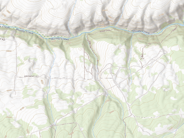
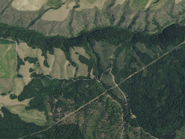
Everything you need — measured from IDL Endowment Land Camping Area — Madison County, ID (43.7003, -111.6038) · Idaho Dept. of Lands · ID
- ShShower6 mi
- GGrocery10 mi
- FFuel10 mi
- RxPharmacy12 mi
- LLaundry12 mi
- +Urgent care12 mi
- HHardware12 mi
- MMechanic12 mi
- OOutfitter12 mi
- @Mail12 mi
- EVEV fast charger12 mi
- DDump21 mi
- WWater23 mi
- AAir-up44 mi
The read: water is a real 23-mi drive, fuel & food sit about 10 mi out.
Not within 60 mi: Propane. Plan those before you head up.
One dot per need — the nearest of each kind, straight-line from camp. Places from OpenStreetMap (© OpenStreetMap contributors); the EV fast charger from the US DOE station locator. Open in Google Maps ↗
The site — IDL Endowment Land Camping Area — Madison County, ID (43.7003, -111.6038)
Nearby & resupply — around IDL Endowment Land Camping Area — Madison County, ID (43.7003, -111.6038) · Idaho Dept. of Lands · ID (OpenStreetMap)
- Water featureMoody Creek (stream) · nearby
- Nearest townHeise · ~5.7 mi
- Drinking waternone within 10 mi
- FuelFuel · ~10.0 mi
- Propane / LPGPropane · ~22.4 mi
- Dump station~21.1 mi
- GroceriesMaverik · ~9.9 mi
- PharmacyHeartland Pharmacy · ~23.7 mi
- Hospital / clinicMadison Memorial Hospital · ~12.0 mi
- HardwarePlatt Electrical Supply · ~13.6 mi
EV charging — from IDL Endowment Land Camping Area — Madison County, ID (43.7003, -111.6038) · Idaho Dept. of Lands · ID — nearest public DC fast & Level 2 (US DOE station data)
- Nearest public DC fast charger12.4 mi straight-line NW — Taylor Chevrolet Buick Cadillac, Rexburg, ID · Blink Network · NACS (Tesla) · 2 fast ports listed · listed open, last confirmed by AFDC 2026-09-16 · hours: 24 hours daily · directions
- Public DC fast stations within reach4 within 25 mi · 13 within 50 · 31 within 100 · 63 within 150
- Nearest listing CCS12.5 mi — Taylor Chevrolet ID, Rexburg
- Nearest listing CHAdeMO24.6 mi — Driggs Community Center, Driggs
- Nearest public Level 2 (J1772)12.2 mi — Eden Apartments, Rexburg, ID · Blink Network · J1772 · 1 Level 2 port listed · listed open, last confirmed by AFDC 2026-09-16 · hours: 24 hours daily
- Pricing at the fast chargernot listed
- Power (kW)not listed by AFDC — “DC fast” spans roughly 24 to 350 kW, so ask the network.
- Read this honestlyStraight-line miles, like every distance on this site. Roads run longer than this, and you have to get back. We know where a charger is listed. We don’t know if it works today, how fast it is, or the road miles. Check the network before you commit.
Snapshot 2026-09-16 · AFDC record 449854 · US DOE Alternative Fuels Data Center
Nearby restrooms — around IDL Endowment Land Camping Area — Madison County, ID (43.7003, -111.6038) · Idaho Dept. of Lands · ID — pit toilets, restrooms & rest areas (government data)
- Vault / pit toiletTablerock Campground · ~4.9 mi S · USFS
- Vault / pit toiletKelly Island Campground - Vault Toilet 2 · ~6.1 mi SW · BLM
- Vault / pit toiletKelly Island Campground - Vault Toilet 1 · ~6.1 mi SW · BLM
- Vault / pit toiletByington Boat Access - Vault Toilet 1 · ~6.2 mi SW · BLM
Open IDL Endowment Land Camping Area — Madison County, ID (43.7003, -111.6038) elsewhere
Other camps near IDL Endowment Land Camping Area — Madison County, ID (43.7003, -111.6038)
If this one is full, gated or washed out.
- Spider Web Camp (IDL Endowment Land)~1.9 mi
- IDL Endowment Land Camping Area — Madison County, ID (43.6684, -111.6272)~2.5 mi
- IDL Endowment Land Camping Area — Madison County, ID (43.6587, -111.5905)~2.9 mi
- IDL Endowment Land Camping Area — Madison County, ID (43.6592, -111.5717)~3.3 mi
How we know this — IDL Endowment Land Camping Area — Madison County, ID (43.7003, -111.6038)
What we don’t know about IDL Endowment Land Camping Area — Madison County, ID (43.7003, -111.6038)
A land record can put you within a few meters of a spot. It cannot tell you any of this — so check it yourself, and treat anything below as the open question it is.
- Road surface & last-mile access
- How many rigs actually fit
- Cell coverage by carrier
- Seasonal & winter access
- Current fire restrictions
- Whether any water here is drinkable
- Shade & wind exposure
- Noise and who else shows up
- Whether a listed EV charger works today, or the road miles to it