Ovando - free town camping (Brand Bar Museum lawn / Valiton Park)
Ovando is a tiny Blackfoot Valley town on MT-200 that has quietly made itself one of the most traveler-friendly stops in Montana. Its community site states flatly: "Camping is free on the grass next to the Brand Bar Museum, on the gravel near the teepee, or at the Ovando Valiton Park at the end of Main Street." Three free spots, all within a couple of blocks, all in town. The pin here is the Brand Bar Museum lawn on Main Street. IMPORTANT -- DO NOT BELIEVE THE BLOGS THAT SAY THE JAIL IS FREE. The ground is free; the three shelters are NOT. The same page says the Shepherd's Wagon, the Teepee, and the Hooscow (the restored 1800s town jail) are "$5-a-night rentals, all proceeds go to the OVANDO COMMUNITY IMPROVEMENT FUND." Five dollars, and it is worth it, but it is not free and travel blogs routinely blur the two. Amenities the town lays on for travelers: an outhouse near the sheep wagon/teepee and by Ovando Park, a porta-potty behind the Shepherd's Wagon, and -- ask at the Blackfoot Commercial Company for the key -- a shower and toilet WITH soap and a towel, plus a laundromat with soap. Clotheslines, mirrors and an LED lantern at the teepee/wagon and hooscow. Horseshoe pits. The Stray Bullet Cafe downtown does breakfast and lunch. The page is written for cyclists (this is an Adventure Cycling route town) and states NO night limit, NO hookups, and NO seasonal dates -- treat all three as unknown. Call Kathy Schoendoerfer at (406) 793-0018 or (406) 793-3474 before you count on anything. Ovando is unincorporated, so this is a community page rather than a town government one -- graded 'med' for that reason, not because the statement is unclear. We have not visited this site.
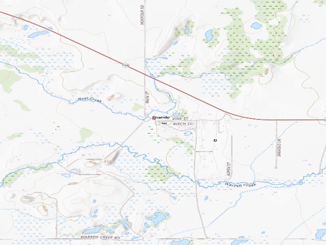
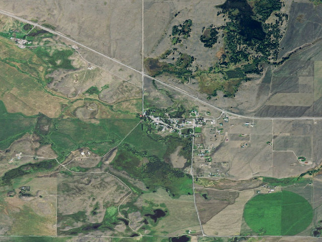
Everything you need — measured from Ovando - free town camping (Brand Bar Museum lawn / Valiton Park) · public land · MT
- @Mail0 mi
- DDump11 mi
- FFuel11 mi
- GGrocery11 mi
- ShShower13 mi
- +Urgent care19 mi
- HHardware20 mi
- LLaundry20 mi
- PPropane24 mi
- WWater29 mi
- OOutfitter41 mi
- MMechanic42 mi
- RxPharmacy42 mi
- AAir-up42 mi
- EVEV fast charger43 mi
The read: water is a real 29-mi drive, fuel & food sit about 11 mi out, the nearest EV fast charger is a 43-mi run (and back).
One dot per need — the nearest of each kind, straight-line from camp. Places from OpenStreetMap (© OpenStreetMap contributors); the EV fast charger from the US DOE station locator. Open in Google Maps ↗
The site — Ovando - free town camping (Brand Bar Museum lawn / Valiton Park)
Nearby & resupply — around Ovando - free town camping (Brand Bar Museum lawn / Valiton Park) · public land · MT (OpenStreetMap)
- Water featureJones Lake (water) · nearby
- Nearest townOvando · ~0.1 mi
- Drinking waternone within 10 mi
- FuelExxon · ~21.7 mi
- Propane / LPGnone within 31 mi
- GroceriesClearwater Stop N Go · ~11.3 mi
- HardwareGrizzly Home Center · ~21.9 mi
EV charging — from Ovando - free town camping (Brand Bar Museum lawn / Valiton Park) · public land · MT — nearest public DC fast & Level 2 (US DOE station data)
- Nearest public DC fast charger43.1 mi straight-line W — Missoula, MT - Tesla Supercharger (at a hotel) · Tesla · NACS (Tesla) · 6 fast ports listed · listed open, last confirmed by AFDC 2026-06-18 · hours: 24 hours daily. Open to Teslas only. · directions
- Public DC fast stations within reachnone within 25 mi · 8 within 50 · 22 within 100 · 43 within 150
- Nearest listing CCS43.6 mi — Missoula Chevrolet, Missoula
- Nearest listing CHAdeMO43.9 mi — Walmart 3259 (Missoula, MT), Missoula
- Nearest public Level 2 (J1772)41.6 mi — UMONTANA UC #1, Missoula, MT · ChargePoint Network · J1772 · 2 Level 2 ports listed · listed open, last confirmed by AFDC 2026-09-16 · hours: 24 hours daily
- Also listed, not counted aboveNACS-only Level 2 — Trixi's Saloon - Tesla Destination, Ovando, 0.4 mi · NACS (Tesla) · hours: 24 hours daily. Open to Teslas only. · AFDC lists it “Free”
- Pricing at the fast chargernot listed
- Power (kW)not listed by AFDC — “DC fast” spans roughly 24 to 350 kW, so ask the network.
- Read this honestlyStraight-line miles, like every distance on this site. Roads run longer than this, and you have to get back. We know where a charger is listed. We don’t know if it works today, how fast it is, or the road miles. Check the network before you commit.
Snapshot 2026-09-16 · AFDC record 102266 · US DOE Alternative Fuels Data Center
Nearby restrooms — around Ovando - free town camping (Brand Bar Museum lawn / Valiton Park) · public land · MT — pit toilets, restrooms & rest areas (government data)
- Vault / pit toiletMonture Creek Trailhead · ~7.5 mi N · USFS
- Vault / pit toiletMonture Guard Station · ~7.5 mi N · USFS
- Vault / pit toiletBig Nelson Campground Complex · ~10.5 mi E · USFS
- Highway rest areaClearwater · ~11.3 mi W
Open Ovando - free town camping (Brand Bar Museum lawn / Valiton Park) elsewhere
Other camps near Ovando - free town camping (Brand Bar Museum lawn / Valiton Park)
If this one is full, gated or washed out.
- Monture 008~5.9 mi
- Mccabe 002~6.2 mi
- Monture 006~6.4 mi
- Monture 001~6.8 mi
Snow, and when this opens
The nearest automatic snow station is N Fk Elk Creek at 6,180 ft, about 12 miles away. It sits about 2,080 ft higher than this camp, so treat it as a guide rather than a reading for this spot. We do not repeat a depth here, because any number we stored would be stale by the time you read it — the station publishes today's.
How we know this — Ovando - free town camping (Brand Bar Museum lawn / Valiton Park)
What we don’t know about Ovando - free town camping (Brand Bar Museum lawn / Valiton Park)
A land record can put you within a few meters of a spot. It cannot tell you any of this — so check it yourself, and treat anything below as the open question it is.
- Road surface & last-mile access
- How many rigs actually fit
- Cell coverage by carrier
- Seasonal & winter access
- Current fire restrictions
- Whether any water here is drinkable
- Shade & wind exposure
- Noise and who else shows up
- Whether a listed EV charger works today, or the road miles to it