Agency-listedMaine BPLFree
Ronco Cove (Moosehead Lake Shoreline Public Land)
Drive-up · public land · ME · 45.67340, -69.64860
Ask an AI about this campsiteOpens Grok already loaded with this site. It reads the same records this page is built from, and links whatever it tells you.
Ask about this camp →The land manager lists this site. Someone from the agency inventoried it, so it is a real camp — not a spot we guessed at. What changes is conditions — roads, gates, closures, fire rules. Check those with the unit before you commit to the drive.
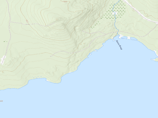
USGS topo — contours & terrain
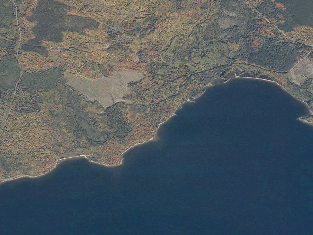
Aerial — USGS / NAIP
Weather outlook — at Ronco Cove (Moosehead Lake Shoreline Public Land)
Loading the latest forecast…
Live NWS area forecast (~2.5 km grid, not elevation-corrected). Camp sits at 1,053 ft.
Fire & smoke — around Ronco Cove (Moosehead Lake Shoreline Public Land)NIFC · AirNow
Checking active fires & air quality…
Active wildfires from NIFC (within ~50 mi); air quality from AirNow. Always confirm current fire restrictions with the managing office before you go.
Everything you need — measured from Ronco Cove (Moosehead Lake Shoreline Public Land) · public land · ME
Straight-line miles · bearings approx · roads run longer
Nearest of each
- FFuel5 mi
- GGrocery5 mi
- DDump8 mi
- @Mail15 mi
- EVEV fast charger16 mi
- ShShower18 mi
- OOutfitter28 mi
- +Urgent care29 mi
- WWater35 mi
- HHardware37 mi
- MMechanic38 mi
- RxPharmacy39 mi
- LLaundry43 mi
- AAir-up58 mi
≤30 mi30–4545+water
The read: water is a real 35-mi drive, fuel & food sit about 5 mi out.
Not within 60 mi: Propane. Plan those before you head up.
One dot per need — the nearest of each kind, straight-line from camp. Places from OpenStreetMap (© OpenStreetMap contributors); the EV fast charger from the US DOE station locator. Open in Google Maps ↗
The site — Ronco Cove (Moosehead Lake Shoreline Public Land)
Access
Drive-up
Land
public land
Elevation
1,053 ft
State
ME
Coordinates
45.67340, -69.64860
Cost
Free
Nearby & resupply — around Ronco Cove (Moosehead Lake Shoreline Public Land) · public land · ME (OpenStreetMap)
- Water featureRonco Brook (stream) · nearby
- Nearest townRockwood · ~4.5 mi
- Drinking waterDrinking water · ~8.0 mi
- FuelFuel · ~4.6 mi
- Propane / LPGnone within 31 mi
- Dump station~8.3 mi
- GroceriesRockwood Convenience Store · ~4.6 mi
- Hospital / clinicNorthern Light CA Dean Hospital · ~15.0 mi
EV charging — from Ronco Cove (Moosehead Lake Shoreline Public Land) · public land · ME — nearest public DC fast & Level 2 (US DOE station data)
- Nearest public DC fast charger15.8 mi straight-line S — Indian Hills Trading Post, Greenville, ME (at a grocery store) · Non-Networked · CCS, NACS (Tesla) · 2 fast ports listed · listed open, last confirmed by AFDC 2025-08-12 · hours: 24 hours daily · directions
- Public DC fast stations within reach2 within 25 mi · 6 within 50 · 50 within 100 · 134 within 150
- Nearest listing CHAdeMO29.3 mi — DC CORRIDOR JACKMAN DC 2, Jackman
- Nearest public Level 2 (J1772)15.8 mi — INDIAN HILL STATION 1, Greenville, ME · ChargePoint Network · J1772 · 2 Level 2 ports listed · listed open, last confirmed by AFDC 2026-09-16 · hours: 24 hours daily
- Pricing at the fast chargernot listed
- Power (kW)not listed by AFDC — “DC fast” spans roughly 24 to 350 kW, so ask the network.
- Read this honestlyStraight-line miles, like every distance on this site. Roads run longer than this, and you have to get back. We know where a charger is listed. We don’t know if it works today, how fast it is, or the road miles. Check the network before you commit.
Snapshot 2026-09-16 · AFDC record 405694 · US DOE Alternative Fuels Data Center
Nearby restrooms — around Ronco Cove (Moosehead Lake Shoreline Public Land) · public land · ME — pit toilets, restrooms & rest areas (government data)
- RestroomMATC Long Pond Stream Lean-to Privy · ~20.9 mi SE · NPS
- RestroomMATC Cloud Pond Lean-to Privy · ~22.7 mi SE · NPS
- RestroomMATC Chairback Gap Lean-to Privy · ~24.1 mi SE · NPS
- RestroomMATC Rainbow Stream Lean-to Privy · ~24.6 mi E · NPS
Open Ronco Cove (Moosehead Lake Shoreline Public Land) elsewhere
Other camps near Ronco Cove (Moosehead Lake Shoreline Public Land)
If this one is full, gated or washed out.
- Outward Bound (Moosehead Lake Shoreline Public Land)~0.4 mi
- Big Dry Point (Moosehead Lake Shoreline Public Land)~1.5 mi
- The Narrows (Moosehead Lake Shoreline Public Land)~1.8 mi
- Cowan East (Moosehead Lake Shoreline Public Land)~2.2 mi
How we know this — Ronco Cove (Moosehead Lake Shoreline Public Land)
Fire rules
Dead and down wood only may be used for campfires. No living trees shall be cut without the Bureau's prior written permission.
Stay limit
14 nights (fourteen days in any 45 day period)
Source
public land records
Confidence
Researched — The record is detailed and internally consistent, and the coordinates land where the managing agency says this site is.
How it was placed
Moosehead Lake Shoreline Public Land, Piscataquis/Somerset County. The guide's Fees section says, verbatim: "The Moosehead Lake Shoreline & Little Moose Public Land campsites are free of charge and available on a first-come, first-served basis." (The same paragraph says day-use fees apply at Mount Kineo State Park and that Lily Bay State Park charges day use and camping fees -- the two Lily Bay campgrounds printed in the same coordinate table, Dunn Point and Rowell Cove, are DELIBERATELY EXCLUDED from this import because they are fee campgrounds.) Facilities: "In addition to nearly 90 campsites at Lily Bay State Park, there are more than 90 other primitive campsites (with fire ring, picnic table and pit or vault toilet) on the shores of Moosehead. Some are accessible by road and many are accessible only by water: see map for details." *** ONE COORDINATE CAN BE MORE THAN ONE TENT SITE: the map labels each location with a site count in brackets -- Spencer Bay (35), Cowan West (18) and so on. Those counts could not be reliably tied to individual coordinates from the extracted text, so each row here is a camping LOCATION, not necessarily a single pitch. *** The guide says public lands on Mt. Kineo, Farm Island and Sugar Island are reachable by water only, and that "Cowan Cove and the Kelly Wharf site can be reached by vehicle"; for every other location the access mode is not stated in text and is left UNKNOWN here rather than guessed. MAINE PUBLIC RESERVED LANDS -- THE RULES THAT APPLY HERE. Fees: maine.gov/dacf/parks/about/public_reserved_lands.shtml (read 2026-08-14) says fees are "Generally not charged; In a few instances such as inside the North Maine Woods, Public Lands are managed in cooperation with neighboring landowners and fees are collected." Reservations: maine.gov/dacf/parks/camping/backcountry_camping.shtml says "Remote campsites are almost exclusively first-come, first-serve; reservations are not generally possible." STAY LIMIT, from the Bureau's own rules page maine.gov/dacf/parks/about/lands_rules.shtml: "No person shall camp, stay overnight or maintain any tent, camper, shelter, trailer or other camping unit on any public lands for more than fourteen days in any 45 day period, without the prior written permission of the Bureau." FIRE: open fires only in authorized campsites with fire rings, or under a Maine Forest Service permit; "Dead and down wood only may be used for campfires. No living trees shall be cut without the Bureau's prior written permission." Untreated firewood from outside Maine is BANNED -- buy it where you burn it. ABANDONED PROPERTY: BPL staff may take custody of personal property left unattended more than 3 days. Hunting and trapping are permitted on these lands in season -- wear blaze orange in the fall. Pets must be leashed and attended in campsites. WATER: BPL does not list drinking water at this site and none is claimed here. These are primitive sites on lakes, ponds and rivers; surface water is NOT represented as potable. Carry water in or treat it. COORDINATE PROVENANCE: latitude and longitude are copied from the "Campsite Latitude / Longitudes" table printed by the Maine Bureau of Parks and Lands in Moosehead Lake Shoreline Public Land guide/map (https://www.maine.gov/dacf/parks/publications_maps/docs/moosehead-lake-shoreline-guide.pdf), downloaded and text-extracted 2026-08-14. This is the agency's own published coordinate for the named site -- it is NOT a geocode, NOT OpenStreetMap and NOT a field visit. No accuracy figure is published with the table. GIS CROSS-CHECK: the point falls INSIDE the state's mapped "Moosehead Lake East Shore" parcel (Maine GeoLibrary, Maine_Conserved_Lands_BPL_Interests, queried 2026-08-14). Nearest town: Rockwood ~4.5 mi -- STRAIGHT-LINE distance to the nearest OpenStreetMap place=city/town/village, NOT a driving distance. In the North Woods the road in is routinely two to four times that on gravel. SEASON: BPL publishes no open/close date for these primitive sites on the guides read this fire. Access is over gravel logging roads that are generally passable June-October (the Machias River guide's words for comparable roads); mud season and snow close them. Confirm with the regional BPL office before a shoulder-season trip. Ingest 2026-08-14. | auto:agency-trust 2026-08-18: state agency GIS record with a source URL and coordinates, confidence not low. Fee value is the agency's own, not field-checked. Not field-verified -- confirm access, road conditions and fire rules before you go.
EV chargers
US DOE Alternative Fuels Data Center station locator, snapshot 2026-09-16. Straight-line miles to the nearest public, open, unrestricted station; restricted and planned units are shown but never counted.
Field check
On the agency's books. The land manager inventoried this site, so its existence is not in question — current conditions are. Nobody from here has camped it recently.
What we don’t know about Ronco Cove (Moosehead Lake Shoreline Public Land)
A land record can put you within a few meters of a spot. It cannot tell you any of this — so check it yourself, and treat anything below as the open question it is.
- Road surface & last-mile access
- How many rigs actually fit
- Cell coverage by carrier
- Seasonal & winter access
- Current fire restrictions
- Whether any water here is drinkable
- Shade & wind exposure
- Noise and who else shows up
- Whether a listed EV charger works today, or the road miles to it
Before you go — Ronco Cove (Moosehead Lake Shoreline Public Land)
Camping near a reservoir →Finding water out here →Cold-weather camping →Camping with a dog →All field notes →
Been here? Tell us what changed. This page is built from public records, so the fastest way it gets better is somebody who has actually pulled in. Road washed out, site gone, gate locked, or it is exactly as described — all of it useful. Send a report →