Agency-listedGeorgia DNR Wildlife Resources DivisionFree

Sprewell Bluff WMA - Tick Farm Campground

Drive-up · public land · GA · 32.87722, -84.48610
Ask an AI about this campsiteOpens Grok already loaded with this site. It reads the same records this page is built from, and links whatever it tells you.
Ask about this camp →
The land manager lists this site. Someone from the agency inventoried it, so it is a real camp — not a spot we guessed at. What changes is conditions — roads, gates, closures, fire rules. Check those with the unit before you commit to the drive.

Nearest town: Thomaston. Designated primitive campground on a Georgia DNR Wildlife Resources Division wildlife management area. Camping on a Georgia WMA is legal only in designated campgrounds (rule 391-4-2-.61). A hunting licence, fishing licence or Lands Pass is required to be on the property. GA DNR publishes no camping fee. No potable water is claimed.
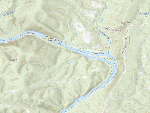
USGS topo — contours & terrain
USGS topographic map of Sprewell Bluff WMA - Tick Farm Campground
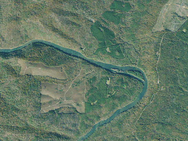
Aerial — USGS / NAIP
Aerial image of Sprewell Bluff WMA - Tick Farm Campground
XFacebookReddit
Weather outlook — at Sprewell Bluff WMA - Tick Farm Campground
Loading the latest forecast…
Live NWS area forecast (~2.5 km grid, not elevation-corrected). Camp sits at 668 ft.
Fire & smoke — around Sprewell Bluff WMA - Tick Farm CampgroundNIFC · AirNow
Checking active fires & air quality…
Active wildfires from NIFC (within ~50 mi); air quality from AirNow. Always confirm current fire restrictions with the managing office before you go.

Everything you need — measured from Sprewell Bluff WMA - Tick Farm Campground · public land · GA

15 MI30 MI60 MIYOUR CAMPN ↑Water · 21 miWDump · 20 miDSave More · Fuel · 9 miFWalmart Supercenter · Grocery · 9 miGWalgreens · Pharmacy · 9 miRxThe Home Depot · Hardware · 9 miHBentley's Automotive · Mechanic · 14 miMLaundry · 20 miLShower · 20 miShAir-up · 24 miADaVita Dialysis · Urgent care · 9 mi+Beyond the Knee · Outfitter · 36 miOManchester Post Office · Mail · 8 mi@GEORGIA POWER WARMSPRINGS DC2 · EV fast charger · 11 miEV
Straight-line miles · bearings approx · roads run longer
Nearest of each
  • @Mail8 mi
  • FFuel9 mi
  • GGrocery9 mi
  • HHardware9 mi
  • RxPharmacy9 mi
  • +Urgent care9 mi
  • EVEV fast charger11 mi
  • MMechanic14 mi
  • LLaundry20 mi
  • ShShower20 mi
  • DDump20 mi
  • WWater21 mi
  • AAir-up24 mi
  • OOutfitter36 mi
≤30 mi30–4545+water

The read: water is a real 21-mi drive, fuel & food sit about 9 mi out.

Not within 60 mi: Propane. Plan those before you head up.

One dot per need — the nearest of each kind, straight-line from camp. Places from OpenStreetMap (© OpenStreetMap contributors); the EV fast charger from the US DOE station locator. Open in Google Maps ↗

The site — Sprewell Bluff WMA - Tick Farm Campground

Access
Drive-up
Land
public land
Elevation
668 ft
State
GA
Coordinates
32.87722, -84.48610
Cost
Free

Nearby & resupply — around Sprewell Bluff WMA - Tick Farm Campground · public land · GA (OpenStreetMap)

  • Water featureTurkey Creek (stream) · nearby
  • Nearest townHickman Forks · ~2.7 mi
  • Drinking waternone within 10 mi
  • FuelSunoco · ~9.2 mi
  • Propane / LPGnone within 31 mi
  • Dump station~20.0 mi
  • GroceriesWalmart Supercenter · ~9.2 mi
  • PharmacyU-Save-It Pharmacy · ~21.4 mi
  • Hospital / clinicUpson Regional Medical Center · ~8.7 mi
  • HardwareFred's · ~29.5 mi

EV charging — from Sprewell Bluff WMA - Tick Farm Campground · public land · GA — nearest public DC fast & Level 2 (US DOE station data)

Nearby restrooms — around Sprewell Bluff WMA - Tick Farm Campground · public land · GA — pit toilets, restrooms & rest areas (government data)

Open Sprewell Bluff WMA - Tick Farm Campground elsewhere

Other camps near Sprewell Bluff WMA - Tick Farm Campground

If this one is full, gated or washed out.

How we know this — Sprewell Bluff WMA - Tick Farm Campground

Stay limit
14 nights (not to exceed 14 consecutive days)
Permit
The WMA License is no longer available or required. A basic hunting or fishing privilege that allows hunting or fishing on state lands is all that is needed to be present on designated state WMAs, state PFAs, and state shooting ranges.
Area rules
All camps or fires shall be in designated campgrounds unless otherwise posted at the check station, except that camping is allowed anywhere on National Forest lands unless otherwise indicated or signed. It is unlawful for any person to use any musical instruments, radios, televisions, generators or other noise making devices after 10:00 p.m. daily, in such a manner that such devices may be heard by other WMA visitors.
Source
public land records
Confidence
Likely — The record is good enough to put a pin on, but thin in places. Treat the details as a starting point, not gospel.
How it was placed
GA DNR layer values for this point, verbatim: Camping='Primitive', Access='Year Round', Maintained='Yes', Management='GM', Comments=None, Name='Tick Farm Campground'. Coordinate is Georgia DNR Wildlife Resources Division's own, unrounded, from the agency's public WMA feature service, layer 6 "Campgrounds" (188 points statewide, read 2026-08-16): https://services6.arcgis.com/9QlSLDqa0P1cHLhu/arcgis/rest/services/WRD_WMA_Public/FeatureServer/6 . Not derived, not geocoded, not rounded by us. SECOND SOURCE - the property's own page (https://georgiawildlife.com/sprewell-bluff-wma-west, read 2026-08-16) affirms camping: "Camping is only allowed in designated areas." - that sentence is on the Sprewell Bluff WMA: WEST page. The EAST page says "no camping allowed on the property." All three GIS points were point-in-polygon tested against GA DNR's own WMA boundary layer (https://services6.arcgis.com/9QlSLDqa0P1cHLhu/arcgis/rest/services/WRD_WMA_Public/FeatureServer/14) and all three returned Tract_Name="Sprewell Bluff West". So all three are on the tract where camping is allowed. FEE BASIS: Georgia DNR prints a "Fees & Passes" block on every property page and none of the 135 WMA pages read this fire names a camping fee. State-managed WMAs and PFAs print "Land Access: Hunting License, Fishing License, or Lands Pass" - i.e. a licence or Lands Pass is required to BE on the property at all, camping or not. GA DNR (https://georgiawildlife.com/LicenseChanges, read 2026-08-16): "The WMA License is no longer available or required." / "A basic hunting or fishing privilege that allows hunting or fishing on state lands is all that is needed to be present on designated state WMAs". We found no first-party page printing the Lands Pass price, so no price is claimed here. This is an ABSENCE-OF-CAMPING-FEE finding, not a published "free" statement; fee=0 means "no camping charge", not "free to enter". REVIEWER: decide whether a pass-gated site should be labelled on a free-camping map. STATEWIDE WMA RULE, Ga. Comp. R. & Regs. R. 391-4-2-.61 (Camping Regulations on Wildlife Management Areas), verbatim: "All camps or fires shall be in designated campgrounds unless otherwise posted at the check station, except that camping is allowed anywhere on National Forest lands unless otherwise indicated or signed."; camping limited to "a period of time not to exceed 14 consecutive days; after which the campsite shall be vacated and all personally owned property or physical features of the camp removed for a period of not less than 7 days."; "It is unlawful for any person to use any musical instruments, radios, televisions, generators or other noise making devices after 10:00 p.m. daily, in such a manner that such devices may be heard by other WMA visitors." SOURCING CAVEAT: Georgia's official rules host (rules.sos.ga.gov) renders rule text via JavaScript and returned no body text; its API paths returned 403. This rule text was read at https://www.law.cornell.edu/regulations/georgia/Ga-Comp-R-Regs-R-391-4-2-.61 (Cornell LII), a REPRODUCTION, NOT a .gov source. Clause (1) is corroborated by GA DNR's own per-property pages. --- REVIEW 2026-08-18 (nightshift-verified) --- PRIMARY SOURCE RE-FETCHED TODAY: GA DNR WRD_WMA_Public FeatureServer layer 6 "Campgrounds", https://services6.arcgis.com/9QlSLDqa0P1cHLhu/arcgis/rest/services/WRD_WMA_Public/FeatureServer/6 - still live, still returns exactly 188 points. This point still exists, at the SAME coordinate to 1e-6 deg (no drift), with the SAME Camping/Access/Maintained/Management/Comments/Name values recorded at discovery. Checked for coordinate duplicates against all 35 published+approved GA camps: nearest is over 250 m away, so this is not a re-listing of something already on the map. TRACT RESOLVED TODAY - this mattered. Sprewell Bluff WMA is split, and the two DNR pages conflict: https://georgiawildlife.com/sprewell-bluff-wma-east says "no camping allowed on the property" while https://georgiawildlife.com/sprewell-bluff-wma-west says "Camping is only allowed in designated areas" and lists Accommodations & Facilities "Primitive Campsites". Point-in-polygon against the agency Boundary layer (FeatureServer/14, read 2026-08-18, Tract_Name='Sprewell Bluff West', OBJECTID 978) puts this campground in the WEST tract, so the camping-allowed page governs. NOTE: the slug the discovery fire used, sprewell-bluff-wma-east, was the WRONG unit - the original audit note's second source did not support the row; today's WEST page does. Layer marks this point Camping='Primitive', Access='Year Round', Maintained='Yes'. VERDICT: HOLDS UP on corrected sourcing -> approved.
EV chargers
US DOE Alternative Fuels Data Center station locator, snapshot 2026-09-16. Straight-line miles to the nearest public, open, unrestricted station; restricted and planned units are shown but never counted.
Field check
On the agency's books. The land manager inventoried this site, so its existence is not in question — current conditions are. Nobody from here has camped it recently.

What we don’t know about Sprewell Bluff WMA - Tick Farm Campground

A land record can put you within a few meters of a spot. It cannot tell you any of this — so check it yourself, and treat anything below as the open question it is.

Before you go — Sprewell Bluff WMA - Tick Farm Campground

Been here? Tell us what changed. This page is built from public records, so the fastest way it gets better is somebody who has actually pulled in. Road washed out, site gone, gate locked, or it is exactly as described — all of it useful. Send a report →