Agency-listedWyoming Game & Fish CommissionFreeOpen today
Springer/Bump Sullivan WHMA Campground
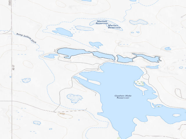
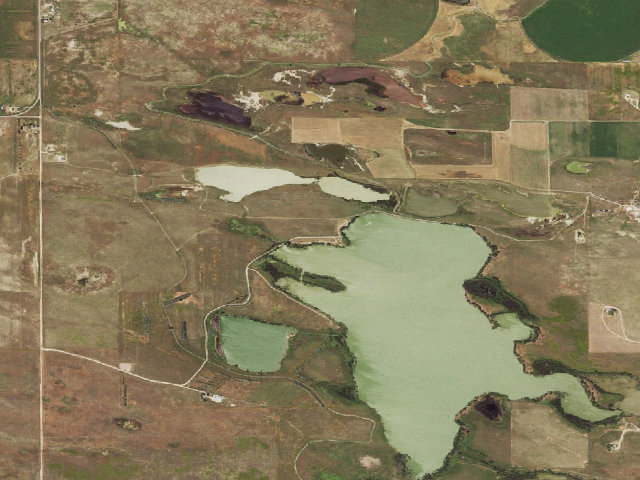
Drive-up · Wyoming Game & Fish · WY · 41.89257, -104.28812
Ask an AI about this campsiteOpens Grok already loaded with this site. It reads the same records this page is built from, and links whatever it tells you.
Wyoming Game & Fish lists this site. Someone from the agency inventoried it, so it is a real camp — not a spot we guessed at. What changes is conditions — roads, gates, closures, fire rules. Check those with the unit before you commit to the drive.
FIRE BAN: WGFD flags this area as 'Fire Ban is in Effect for this Area' -- check before you plan on any open flame. SEASONAL CLOSURE -- READ THIS FIRST: Vehicular closure Oct. 1 - May 15 Wyoming closes many of these areas in winter and spring to protect wintering big game, and a closure is not advisory. Confirm the current dates with Game and Fish before you drive out. This is a designated campground on the Springer/Bump Sullivan Wildlife Habitat Management Area in Goshen County, land acquired or administered by the Wyoming Game and Fish Commission. The area runs about 3,416 acres. Camping here is genuinely free and first come, first served -- and unlike neighbouring states, Wyoming does NOT make you buy a license or a habitat/entrance pass simply to be on the land or to camp. (If you intend to hunt or fish while you are there, that is a different matter: you need the appropriate Wyoming license and a conservation stamp for that activity.) The rules that bind: you may only camp in the designated spots, no more than 14 consecutive days, and you cannot leave a camp unattended more than 48 hours. After you hit the limit you have to be off that same Game and Fish land for at least 72 hours before returning. Some areas post a limit shorter than 14 days on the sign at the entrance -- if the sign says less, the sign wins. Area-specific regulations from Game and Fish: Motor Vehicle Travel Restricted to Roads Marked By white arrow on the Wildlife Habitat Management Area. Waterfowl Hunting Closure around Springer Reservoir and restrictions of shotgun and archery equipment are marked with Department Signs. ORV use is prohibited. 14-day camping limit. Exceptions noted for this area: Closure is limited to vehicles only. Foot and horse access open year-round. No Shooting within 300 yards of school as marked with department signs. Amenities listed by Game and Fish for the area: Parking, Comfort Stations, Boat Ramp, Hunting blinds with priority given to early arrivals. Accessibility: WGFD marks this facility 'Accessible'. These are working wildlife areas first and campgrounds second -- they exist for habitat, so expect gravel, expect stock, and leave it cleaner than you found it. We have not visited; confirm current conditions and closures with the Wyoming Game and Fish Laramie regional office before you go.
Can I go now? — Springer/Bump Sullivan WHMA Campground · Wyoming Game & Fish · WY
Open todayOpened for motor vehicles May 16; the record gives no closing date.
Wyoming Game & Fish record: “Vehicular closure Oct. 1 - May 15” · also: “Foot and horse access open year-round. THIS AREA OPENS TO MOTORIZED VEHICLES ON MAY 16.” Read against the calendar on 2026-09-17; with JavaScript your browser re-checks it against today.
🔥 Fire ban recorded in the agency listing when it was last read (“Fire Ban is in Effect for this Area”). That is a snapshot, not a live feed — check current restrictions before you light anything.
Nearby & resupply — around Springer/Bump Sullivan WHMA Campground · Wyoming Game & Fish · WY(OpenStreetMap)
Water featureWater · nearby
Nearest townYoder · ~1.7 mi
Drinking waternone within 10 mi
FuelWTT · ~12.9 mi
Propane / LPGnone within 31 mi
GroceriesStore · ~1.7 mi
PharmacyCommunity Drug · ~13.0 mi
Hospital / clinicCommunity Hospital · ~14.0 mi
EV charging — from Springer/Bump Sullivan WHMA Campground · Wyoming Game & Fish · WY— nearest public DC fast & Level 2 (US DOE station data)
Nearest public DC fast charger31.7 mi straight-line E — NPPD EV STATION SB SINCLAIR DCS, Scottsbluff, NE · ChargePoint Network · CHAdeMO, CCS · 1 fast port listed · listed open, last confirmed by AFDC 2026-09-16 · hours: 24 hours daily · directions
Public DC fast stations within reachnone within 25 mi · 3 within 50 · 29 within 100 · 183 within 150
Nearest public Level 2 (J1772)32.0 mi — HAMPTON INN SCB HAMPTON INN SCB, Scottsbluff, NE · ChargePoint Network · J1772 · 2 Level 2 ports listed · listed open, last confirmed by AFDC 2026-09-16 · hours: 24 hours daily
Pricing at the fast chargernot listed
Power (kW)not listed by AFDC — “DC fast” spans roughly 24 to 350 kW, so ask the network.
Read this honestlyStraight-line miles, like every distance on this site. Roads run longer than this, and you have to get back. We know where a charger is listed. We don’t know if it works today, how fast it is, or the road miles. Check the network before you commit. Snapshot 2026-09-16 · AFDC record 359949 · US DOE Alternative Fuels Data Center
Nearby restrooms — around Springer/Bump Sullivan WHMA Campground · Wyoming Game & Fish · WY— pit toilets, restrooms & rest areas (government data)
How we know this — Springer/Bump Sullivan WHMA Campground
Seasonal closure
Vehicular closure Oct. 1 - May 15
Fire ban
Fire Ban is in Effect for this Area
Open dates
Foot and horse access open year-round. THIS AREA OPENS TO MOTORIZED VEHICLES ON MAY 16.
Stay limit
14 nights (14-day camping limit)
Area rules
Motor Vehicle Travel Restricted to Roads Marked By white arrow on the Wildlife Habitat Management Area. Waterfowl Hunting Closure around Springer Reservoir and restrictions of shotgun and archery equipment are marked with Department Signs. ORV use is prohibited. 14-day camping limit.
Exceptions
Closure is limited to vehicles only. Foot and horse access open year-round. No Shooting within 300 yards of school as marked with department signs.
Amenities
Parking, Comfort Stations, Boat Ramp, Hunting blinds with priority given to early arrivals.
Source
Wyoming Game & Fish (habitat management areas)
Confidence
Researched — The record is detailed and internally consistent, and the coordinates land where the managing agency says this site is.
How it was placed
FREE, no permit required, per WGFC Chapter 23 Sec. 4(a)(iii): 'Camping shall only be allowed in areas designated by Department publication or sign. No person shall camp in excess of the posted camping limit, and in no case more than fourteen (14) consecutive days, or leave a camp unattended for more than forty-eight (48) hours.' The words 'fee' and 'stamp' do not appear anywhere in Chapter 23, and 'license' appears only for long-term special-use agreements -- there is NO license/pass precondition for camping (unlike SD GFP or OK ODWC). WGFD states directly: 'Camping on WHMAs and PAAs is free and on a first-come, first-served basis' and 'The statewide camping limit is 14 days'. DESIGNATION: this is not inferred -- it is a point in WGFD's own WHMA_Facilities feature service with FacilityType='Campground' and PublicView='Public' (FacilityName 'Campground', area 'Springer/Bump Sullivan'), which is the 'Department publication' the rule requires. Coordinates are that feature's own WGS84 geometry, not a geocode. Area attributes (season, regulations, amenities) come from WGFD's WHMA_Locations layer joined on area name. Source: services6.arcgis.com/cWzdqIyxbijuhPLw (WHMA_Facilities / WHMA_Locations), WGFD open data. Ingested 2026-07-20 18:27:48. SCOPE OF THE RULE (checked 2026-07-21 against the Chapter 23 PDF itself, wgfd.wyo.gov/sites/default/files/attachments/24576_REGULATIONS-CH-23.pdf): the chapter is titled 'REGULATION GOVERNING USES OF LANDS AND WATERS ACQUIRED OR ADMINISTERED BY THE WYOMING GAME AND FISH COMMISSION', and Sec. 3 defines acquired land as taken by the Commission 'by purchase, deed, lease, agreement, gift or devise'. The rule therefore reaches land the Commission holds by lease/agreement/easement, not only land it owns, so the free-camping authority holds on easement areas too. Land status is stated as 'acquired or administered' rather than 'owned' for that reason. SeasonalClosure: 'Vehicular closure Oct. 1 - May 15'. AccessDates: 'Foot and horse access open year-round. THIS AREA OPENS TO MOTORIZED VEHICLES ON MAY 16.'. AreaRegulations: 'Motor Vehicle Travel Restricted to Roads Marked By white arrow on the Wildlife Habitat Management Area. Waterfowl Hunting Closure around Springer Reservoir and restrictions of shotgun and archery equipment are marked with Department Signs. ORV use is prohibited. 14-day camping limit.'. Exceptions: 'Closure is limited to vehicles only. Foot and horse access open year-round. No Shooting within 300 yards of school as marked with department signs.'. Amenities: 'Parking, Comfort Stations, Boat Ramp, Hunting blinds with priority given to early arrivals.'. FireBan: 'Fire Ban is in Effect for this Area'. NOTE REFRESHED 2026-07-21 01:39:46: this row's stay limit was recomputed after a parser fix -- WGFD states its posted camping limit in several different phrasings ('Camping limit: 5 days', 'Overnight camping (5-day limit)', '5 day camping on Commission Lands') and the original ingester matched only one of them, so some areas were described with Wyoming's 14-day statewide cap when the posted limit is shorter. Coordinates, source and provenance are unchanged.
Season
Read from the agency's own season / closure text in this record (data/conditions.py) and checked against the calendar. The words we read are printed under the verdict at the top of the page.
EV chargers
US DOE Alternative Fuels Data Center station locator, snapshot 2026-09-16. Straight-line miles to the nearest public, open, unrestricted station; restricted and planned units are shown but never counted.
Field check
On the agency's books. The land manager inventoried this site, so its existence is not in question — current conditions are. Nobody from here has camped it recently.
What we don’t know about Springer/Bump Sullivan WHMA Campground
A land record can put you within a few meters of a spot. It cannot tell you any of this — so check it yourself, and treat anything below as the open question it is.
Road surface & last-mile access
How many rigs actually fit
Cell coverage by carrier
Current fire restrictions
Whether any water here is drinkable
Shade & wind exposure
Noise and who else shows up
Whether a listed EV charger works today, or the road miles to it
Before you go — Springer/Bump Sullivan WHMA Campground
Been here? Tell us what changed. This page is built from public records, so the fastest way it gets better is somebody who has actually pulled in. Road washed out, site gone, gate locked, or it is exactly as described — all of it useful. Send a report →