Wilcox Lake Trail Campsite (Wilcox Lake Wild Forest)
FREE primitive camping. DEC-designated primitive tent site ('Wilcox Lake Trail Campsite') in the Wilcox Lake Wild Forest, part of New York's Adirondack Forest Preserve, in the southern Adirondacks between Northville and Stony Creek (Hamilton, Warren and Saratoga County). New York's Forest Preserve allows backcountry camping at these designated sites at NO CHARGE (the DEC unit page lists the fee as 'Free'), first-come/first-served -- these backcountry sites cannot be reserved. A FREE New York State Forest Ranger permit is required ONLY if you stay more than 3 nights in one spot or camp in a group of 10 or more; otherwise no permit and no fee. Camp only at the marked site (look for the yellow 'Camp Here' disc). This is a primitive site: no hookups, no potable water, pack out all trash, follow Leave No Trace and the DEC fire rules. This site is named for a pond/lake/creek, so it may require a short hike or a paddle to reach; confirm access on the DEC unit page. Rules and site status change -- confirm with the DEC unit page (dec.ny.gov/places/wilcox-lake-wild-forest) or a regional DEC office before you go; we have not visited.
Everything you need — measured from Wilcox Lake Trail Campsite (Wilcox Lake Wild Forest) · New York State Dept. of Environmental Conservation · NY
- GGrocery10 mi
- +Urgent care10 mi
- RxPharmacy10 mi
- @Mail10 mi
- FFuel11 mi
- HHardware11 mi
- LLaundry11 mi
- MMechanic11 mi
- ShShower12 mi
- DDump12 mi
- WWater12 mi
- OOutfitter19 mi
- AAir-up22 mi
- EVEV fast charger24 mi
The read: water's a short hop out, fuel & food sit about 10 mi out.
Not within 60 mi: Propane. Plan those before you head up.
One dot per need — the nearest of each kind, straight-line from camp. Places from OpenStreetMap (© OpenStreetMap contributors); the EV fast charger from the US DOE station locator. Open in Google Maps ↗
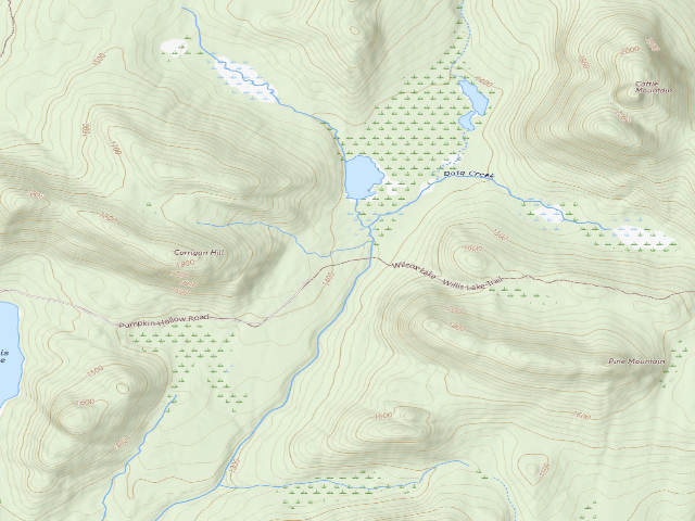
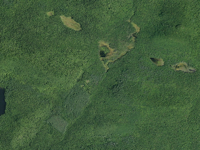
The site — Wilcox Lake Trail Campsite (Wilcox Lake Wild Forest)
Nearby & resupply — around Wilcox Lake Trail Campsite (Wilcox Lake Wild Forest) · New York State Dept. of Environmental Conservation · NY (OpenStreetMap)
- Water featureWillis Lake (water) · nearby
- Nearest townPumpkin Hollow · ~2.6 mi
- Drinking waternone within 10 mi
- FuelStewart's · ~10.6 mi
- Propane / LPGPropane · ~29.9 mi
- Dump station~12.1 mi
- GroceriesTops · ~10.4 mi
- PharmacyWalgreens · ~10.5 mi
- Hospital / clinicNathan Littauer Hospital · ~21.7 mi
- HardwareAllen & Palmer True Value · ~10.6 mi
EV charging — from Wilcox Lake Trail Campsite (Wilcox Lake Wild Forest) · New York State Dept. of Environmental Conservation · NY — nearest public DC fast & Level 2 (US DOE station data)
- Nearest public DC fast charger24.2 mi straight-line E — Warren Ford, Warrensburg, NY (at a public site) · FORD_CHARGE · CCS · 2 fast ports listed · listed open, last confirmed by AFDC 2026-09-16 · hours: 24 hours daily · directions
- Public DC fast stations within reach1 within 25 mi · 72 within 50 · 311 within 100 · 746 within 150
- Nearest listing NACS (Tesla)25.6 mi — Aldi Johnstown TUL 110, Johnstown
- Nearest listing CHAdeMO29.0 mi — GMG DCFC FORT EDWARD #1, Fort Edward
- Nearest public Level 2 (J1772)10.6 mi — Timeless Tavern, Northville, NY (at a parking lot) · Non-Networked · J1772 · 2 Level 2 ports listed · listed open, last confirmed by AFDC 2024-08-15 · hours: 24 hours daily
- Pricing at the fast chargernot listed
- Power (kW)not listed by AFDC — “DC fast” spans roughly 24 to 350 kW, so ask the network.
- Read this honestlyStraight-line miles, like every distance on this site. Roads run longer than this, and you have to get back. We know where a charger is listed. We don’t know if it works today, how fast it is, or the road miles. Check the network before you commit.
Snapshot 2026-09-16 · AFDC record 358294 · US DOE Alternative Fuels Data Center
Nearby restrooms — around Wilcox Lake Trail Campsite (Wilcox Lake Wild Forest) · New York State Dept. of Environmental Conservation · NY — pit toilets, restrooms & rest areas (government data)
- Highway rest areaGlens Falls (South) · ~28.2 mi E
- Highway rest areaAdirondacks Welcome Center · ~28.4 mi E
Open Wilcox Lake Trail Campsite (Wilcox Lake Wild Forest) elsewhere
Other camps near Wilcox Lake Trail Campsite (Wilcox Lake Wild Forest)
If this one is full, gated or washed out.
- Wilcox Lake Trail Campsite (Wilcox Lake Wild Forest)~0.4 mi
- Wilcox Lake Trail Campsite (Wilcox Lake Wild Forest)~0.9 mi
- Willis Lake Campsite (Wilcox Lake Wild Forest)~1.0 mi
- Murphy Lake Tent Site (Wilcox Lake Wild Forest)~2.5 mi
How we know this — Wilcox Lake Trail Campsite (Wilcox Lake Wild Forest)
What we don’t know about Wilcox Lake Trail Campsite (Wilcox Lake Wild Forest)
A land record can put you within a few meters of a spot. It cannot tell you any of this — so check it yourself, and treat anything below as the open question it is.
- Road surface & last-mile access
- How many rigs actually fit
- Cell coverage by carrier
- Seasonal & winter access
- Current fire restrictions
- Whether any water here is drinkable
- Shade & wind exposure
- Noise and who else shows up
- Whether a listed EV charger works today, or the road miles to it