Oglala National Grassland
Where the camps cluster
The place
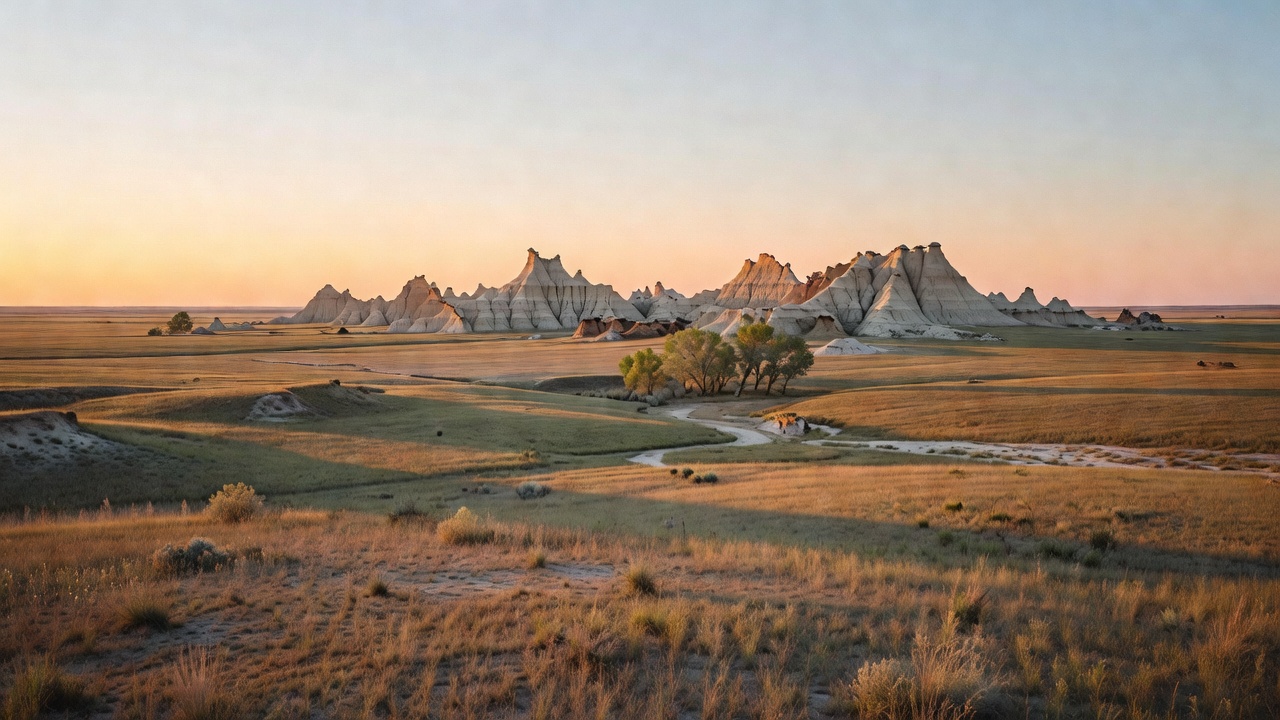
The Oglala National Grassland occupies the extreme northwest corner of Nebraska -- northern Sioux and northwestern Dawes counties, up against both the South Dakota and Wyoming lines. The town you stage out of is Crawford, five miles south of the turnoff. The Forest Service describes the country in its own flat language as native mixed-grass prairie, with forested streambeds and steep, worn formations created by water and wind erosion on layers of siltstone and clay. That last clause is doing a lot of work. What it means on the ground is badlands: bare, banded, crumbling gray-and-tan buttes cut into the flank of the Pine Ridge escarpment, which is the long broken rim between the Niobrara and the White rivers that gives this corner of Nebraska its ponderosa pine, its buttes and canyons, and an ecology that has more in common with the Black Hills fifty miles north than with the rest of the state. Along the drainages you get eastern cottonwood, green ash and peachleaf willow; everywhere else it is grass and sky.
Do not picture a forest. There is no canopy here, no shade to speak of, and no trees except in the creek bottoms and on the ridge to the south. What there is instead is horizon, and a set of very specific reasons to drive a long way for it.
Getting in is simple and unforgiving in equal measure. From Crawford you take Nebraska Highway 2 north about five miles to Toadstool Road, then west roughly fifteen miles; coming down from Hot Springs, South Dakota, it is about sixty miles south on Highway 71 to the same Toadstool Road, then west about fifteen. Those last fifteen miles are the whole problem. The Forest Service says the area is open year-round but that the roads become impassable when wet, and recommends four-wheel drive after any precipitation. On prairie clay that is not boilerplate -- a thunderstorm can take a graded road out of service in twenty minutes, and there is no cell coverage worth relying on to tell anyone about it. Check the weather before you commit, and if the sky looks serious while you are out there, leave early rather than late.
The grassland is administered by the Nebraska National Forests and Grasslands out of Chadron, Nebraska, the same office that runs the Nebraska and Samuel R. McKelvie National Forests and the Buffalo Gap and Fort Pierre National Grasslands. The district you actually want is Pine Ridge, at 308-432-0300, open 9 to 4 weekdays Mountain time. Call them about road conditions and current fire restrictions; the unit runs seasonal open-fire prohibitions and they are the ones who know what is in force today.
Dispersed camping follows the rules the Nebraska National Forests and Grasslands publishes for its units: a maximum of 14 nonconsecutive days in any 30-day period, camp 100 feet from any creek or stream and half a mile from developed recreation sites, and keep motor vehicles within 300 feet of roads shown on the Motor Vehicle Use Map. You may walk and camp farther out than 300 feet; you just cannot drive there. The MVUM is the legally live answer to where you can drive -- not this page, not your mapping app. Get the current one.
History
This prairie is federal land for the same reason most of the national grasslands are: the farming failed, and the government bought the wreckage.
The story runs through the Dust Bowl. The federal soil-conservation apparatus was built on the fly as the plains blew away -- the Soil Erosion Service stood up in the Interior Department on September 13, 1933, moved to Agriculture in March 1935, and was folded into the new Soil Conservation Service under the Soil Conservation and Domestic Allotment Act later that year. In 1937 Congress passed the Bankhead-Jones Farm Tenant Act, which gave the federal government standing authority to retire submarginal land -- ground that should not have been plowed in the first place -- and manage it for conservation. Land bought under that program and its Depression-era predecessors was held as Land Utilization Projects for decades before it got a proper name. The designation 'national grassland' did not exist until 1960. Today there are twenty of them, totaling roughly 3.8 million acres, nearly all on or near the Great Plains, and this is one of the smaller ones.
The Civilian Conservation Corps left its handwriting all over this place. During the 1930s CCC crews built around one hundred ponds and a few reservoirs out here for livestock water, and those ponds are still the reason there is fishing on a semi-arid grassland. The other artifact of the homestead era is a building you can walk into: in 1984 the Forest Service put up a sod house near the site of one built in 1929, because sod was the only construction material anybody out here had in quantity. It sits by the campground at Toadstool, and it makes the point about this country faster than any interpretive sign could -- people tried to live here in dirt houses, and then they left.
Long before that, the grassland was inside the native range of the American bison, and it was contested ground in the Indian Wars that swept this corner of Nebraska in the 1870s. On July 17, 1876 -- three weeks after the Little Bighorn -- roughly 350 troopers of the 5th Cavalry under Colonel Wesley Merritt ambushed a Cheyenne party in what is now Sioux County. Merritt had hidden his men in covered wagons; when a small war party charged what looked like an unescorted train, the trap closed. William F. Cody, scouting for Merritt, shot and killed a Cheyenne warrior named Yellow Hair and scalped him. One Cheyenne died; no soldiers were killed or wounded. It was a skirmish, not a battle, and Cody spent the rest of his career selling it -- staging it in his Wild West show as 'The Red Right Hand, or, Buffalo Bill's First Scalp for Custer.' The Warbonnet Battlefield Monument stands on the grassland today, on Montrose Road. The larger history it sits inside is nearby and grimmer: Crazy Horse was killed at Fort Robinson, just south of here, in 1877, and the Cheyenne Outbreak began at the same post in 1879.
And there is one more piece of history here that is still an open argument, which is the best kind. In 1954 two local ranchers, Bill Hudson and Albert Meng, were digging a stock pond and hit bone. What they had found was the remains of up to 600 bison, roughly ten thousand years old -- not modern bison but an animal transitional between the extinct Bison antiquus and the one we have now. Dr. Larry Agenbroad excavated more than 400 square meters of it in the 1970s and interpreted it as a kill site, at the time the largest Alberta-culture bison kill ever found; the site went on the National Register of Historic Places on August 28, 1973. Then in the 1990s Larry Todd and David Rapson re-examined it and concluded the animals had died of unknown natural causes and that it was not a kill site at all. Excavations in 2005 and 2006 turned up both Alberta and Eden cultural material. Three teams have now worked the bonebed and the Forest Service's official position is refreshingly honest: the mystery is unsolved, and visitors are invited to look at it and decide for themselves.
Wildlife & plants
Pronghorn are the headline. The Forest Service says flatly that the Oglala is the best place in Nebraska to view them, and open, lightly-traveled mixed-grass prairie is exactly the habitat that makes that true -- pronghorn evolved for speed and sightlines, and this is a country made of sightlines. Bring binoculars. Along the grassland's northern border there are black-tailed prairie dog colonies, which are worth stopping for on their own account and also because prairie dog towns are where a disproportionate amount of prairie wildlife concentrates.
Over one hundred bird species and fifty mammals have been recorded here. The commoner large animals are mule and white-tailed deer, pronghorn, coyote, elk and wild turkey. Sharp-tailed grouse hold scattered leks -- dancing grounds -- across the unit. The sensitive-species list is the more interesting document, because it tells you what this landscape is actually for: fringed myotis bat, black-tailed prairie dog, swift fox, ferruginous hawk (one to three active nests in a typical year), northern harrier, long-billed curlew with several colonies out in the pastures, burrowing owl, short-eared owl, migrating American peregrine falcon, loggerhead shrike, McCown's and chestnut-collared longspurs, and northern leopard frog. That is a roll call of grassland specialists, most of which are in trouble across their range for the plain reason that there is not much unplowed prairie left. This is some.
The grassland is also within the native range of the American bison, which is worth saying out loud given what is buried in the ground here.
The plant show runs all season and rewards anyone willing to look down. Spring brings Missouri milk vetch, shell-leaf penstemon, gumbo lily and death camas. Summer brings yellow evening primrose, ten-petal blazing star, slimflower scurfpea and spiderwort out across the open grass. By fall it is goldenrods and broom snakeweed closing the season out. Along the drainages the woody species are eastern cottonwood, green ash and peachleaf willow -- the only real trees on the unit, which is why those creek bottoms hold so much of the bird life.
Notable features
Toadstool Geologic Park is the reason most people come, and it earns it. The name is literal: fast rivers running off the Rockies and the Black Hills laid down coarse sand that cemented into hard sandstone, and as the climate dried the sandstone weathered slower than the soft siltstone under it, leaving slabs balanced on narrow pedestals like enormous mushrooms. The stratigraphy stacks the Eocene Chadron Formation at the bottom and the Oligocene Brule Formation above it -- the two halves of the White River Group, the same sequence that makes the Big Badlands of South Dakota. The National Park Service brackets the rock exposed at Toadstool at 38 to 24 million years old. The badlands here sit on the flank of the Pine Ridge escarpment, and the section is scientifically valuable because it links the Big Badlands of South Dakota to correlative deposits in Wyoming, with volcanic ash beds interleaved through the section that let researchers date the layers directly. The fossils are the same cast as the South Dakota badlands: ancient dogs (Hesperocyon), three-toed horses (Mesohippus), early rhinos (Subhyracodon), and the extinct things with no modern equivalent -- brontotheres, oreodonts and entelodonts. The single strangest thing exposed here is a three-quarter-mile-long fossil trackway, which the Park Service reads as a pursuit: entelodonts chasing two species of rhinoceros down a stream channel. A chase, printed in mud, tens of millions of years ago.
Three walks leave the campground. The 1-mile interpretive loop is the one to do if you only do one -- it runs through the best of the hoodoos with signs and a self-guided brochure, and takes an hour or so. The Bison Trail runs three miles one way through the canyon to the Hudson-Meng Education and Research Center. A 5-mile loop ties into the Great Plains Trail network for a bigger day through badlands and grassland. Note the rule that governs all of it: collecting fossils or artifacts is prohibited by federal law. Rock collecting is allowed on the trail system -- rocks, not fossils, and if you cannot tell the difference, leave it.
The campground at Toadstool has 12 sites with picnic tables, fire rings, upright grills, and two accessible vault toilets. There is no potable water -- none, not seasonally, haul your own. Day use runs $3 per vehicle per day and a campsite is $15 a night including one vehicle, with a second vehicle $7.50. It is open year-round, subject to those roads. The reconstructed sod house stands right there. Confirm current fees with the Pine Ridge Ranger District before you count on them.
At the far end of the Bison Trail, the Hudson-Meng Education and Research Center is built over the bonebed itself, so you are looking down at bison lying where they died about ten thousand years ago -- the largest bison bonebed of its age in North America. It is a seasonal, part-time operation and you must plan around it: for the 2026 season it is open Fridays 9 to 4 Mountain time from May 29 through Labor Day weekend, tours are by appointment, and admission is $5 per adult per day. Call the district. Showing up on a Tuesday gets you a locked building at the end of fifteen miles of dirt.
Elsewhere on the unit: the Warbonnet Battlefield Monument on Montrose Road, the CCC-built stock ponds and reservoirs that locals and visitors fish, and a trail system open to hiking, mountain biking and hunting. What there is not is a fee booth, a store, a water spigot, or anybody to help you. That is most of the appeal.
Camps are sourced from public U.S. Forest Service recreation data and have not been personally visited. Roads shown are Forest Service passenger-car routes (maintenance level 3–5) and may be seasonal or gated. Always confirm access, fees and fire rules with the ranger district before you go. Found a fee where we show free? Tell us on the contact page.