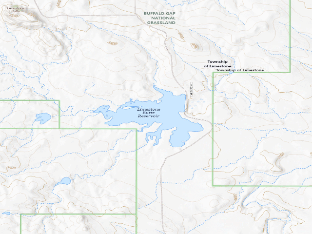
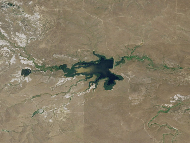
Drive-up · U.S. Forest Service · SD · 43.16010, -103.16697
Ask an AI about this campsiteOpens Grok already loaded with this site. It reads the same records this page is built from, and links whatever it tells you.
U.S. Forest Service lists this site. On most of their ground you can camp away from developed sites pretty much anywhere — so treat this as a known-good spot, not the only one allowed. The unit sets stay limits and how far off road and water you must be. What changes is conditions — roads, gates, closures, fire rules. Check those with the unit before you commit to the drive.
A quiet free dispersed camping spot on the Buffalo Gap National Grassland a few minutes east of Oelrichs, in the far southwest corner of South Dakota near the Nebraska line. The Forest Service describes it as "A scenic area for wildlife viewing, dispersed camping, hiking and rockhounding. Limestone Butte Reservoir is popular with hunters and gets many waterfowl visitors. No fishing available. Please recreate with respect and pack out all trash." Fees: "No fee required." NO POTABLE WATER -- the Forest Service states "Potable water is not available at this site." There is a reservoir, but reservoir water is not drinking water and we are not telling you it is. Bring your own. No picnic tables either. Horses are allowed. This is birdwatching and hunting country more than scenery-tourism country. Expect waterfowl on the reservoir and hunters in season. READ THE COORDINATE WARNING BELOW BEFORE YOU DRIVE HERE -- the pin is our best estimate from official data, not a Forest Service-published campsite location. Grassland-wide dispersed rules apply: 14 nonconsecutive days in any 30-day period, camp 100 feet back from water, vehicles no more than 300 feet off a road shown on the Motor Vehicle Use Map. Check fire restrictions before lighting anything. Fall River Ranger District, (605) 745-4107. We have not visited this site.
Nearby & resupply — around Limestone Butte · U.S. Forest Service · SD(OpenStreetMap)
Nearest townSmithwick · ~9.8 mi
Drinking waternone within 10 mi
FuelSinclair · ~20.1 mi
Propane / LPGnone within 31 mi
GroceriesCoffee Cup Travel Plaza · ~20.1 mi
PharmacyLynn's Dakotamart Pharmacy · ~24.0 mi
HardwareAce Hardware · ~24.1 mi
EV charging — from Limestone Butte · U.S. Forest Service · SD— nearest public DC fast & Level 2 (US DOE station data)
Nearest public DC fast charger24.1 mi straight-line S — NPPD EV STATION CHDRN BGBTS DCN, Chadron, NE · ChargePoint Network · CHAdeMO, CCS · 1 fast port listed · listed open, last confirmed by AFDC 2026-09-16 · hours: 24 hours daily · directions
Public DC fast stations within reach2 within 25 mi · 3 within 50 · 18 within 100 · 28 within 150
Nearest public Level 2 (J1772)24.3 mi — CHADRON CHADRON 1 · ChargePoint Network · J1772 · 2 Level 2 ports listed · listed open, last confirmed by AFDC 2026-09-16 · hours: 24 hours daily
Also listed, not counted aboveNACS-only Level 2 — Hot Springs Hills Inn - Tesla Destination, Hot Springs, 23.9 mi · NACS (Tesla) · hours: 24 hours daily. Open to Teslas only. · AFDC lists it “Free”
Pricing at the fast chargernot listed
Power (kW)not listed by AFDC — “DC fast” spans roughly 24 to 350 kW, so ask the network.
Read this honestlyStraight-line miles, like every distance on this site. Roads run longer than this, and you have to get back. We know where a charger is listed. We don’t know if it works today, how fast it is, or the road miles. Check the network before you commit. Snapshot 2026-09-16 · AFDC record 311797 · US DOE Alternative Fuels Data Center
Nearby restrooms — around Limestone Butte · U.S. Forest Service · SD— pit toilets, restrooms & rest areas (government data)
Camping not stated — The agency's page implies overnight use -- typically by posting a stay limit -- but never actually says camping is allowed. Worth a call to the field office before you commit to it.
How it was placed
SOURCE: USDA Forest Service, https://www.fs.usda.gov/r02/nebraska/recreation/limestone-butte -- downloaded raw this fire to data/_scratch_sd/fs_limestone-butte.html and read locally. Quotes verbatim: "A scenic area for wildlife viewing, dispersed camping, hiking and rockhounding."; "No fee required."; "Potable water is not available at this site."; "Picnic tables are not available at this site."; Directions: "Located 5 minutes east of Oelrichs on Highway 18." Page last updated March 19, 2025. *** COORDINATE IS AN ESTIMATE AND THAT IS THE WEAK POINT OF THIS ROW *** The Forest Service page publishes NO latitude/longitude for this site -- unlike Railroad Buttes and Baja -- and the site does not appear in the EDW recreation-site layer at all. The pin used, 43.1601017,-103.1669697, is the USGS GNIS point for LIMESTONE BUTTE RESERVOIR, Fall River County (feature class Reservoir), taken from the official USGS Domestic Names file https://prd-tnm.s3.amazonaws.com/StagedProducts/GeographicNames/DomesticNames/DomesticNames_SD_Text.zip downloaded this fire. The reservoir was chosen over the summit because the Forest Service's own description is built around the reservoir. For reference GNIS puts the SUMMIT 'Limestone Butte' at 43.1734726,-103.1849355, about 1.4 miles northwest -- so the true camping area could be anywhere in roughly a 1.5 mile spread. Corroboration that this is the right neighbourhood: Oelrichs sits at about 43.18,-103.23; the reservoir point is roughly 3.5 miles east-southeast of it, which agrees with the Forest Service's "5 minutes east of Oelrichs on Highway 18". Point-in-polygon against https://apps.fs.usda.gov/arcx/rest/services/EDW/EDW_BasicOwnership_01/MapServer/0 puts BOTH the reservoir point and the summit point inside ownerclassification='USDA FOREST SERVICE', forestname='Nebraska National Forest', so the land status is not in doubt even though the exact spot is. Confidence 'med' for that reason. A reviewer with a Fall River Ranger District MVUM could tighten this pin considerably. Dedupe: nearest existing row in the database is more than 3 km away. Verified 2026-08-17 01:05:16. | auto:agency-trust 2026-08-18: state agency GIS record with a source URL and coordinates, confidence not low. Fee value is the agency's own, not field-checked. Not field-verified -- confirm access, road conditions and fire rules before you go.
EV chargers
US DOE Alternative Fuels Data Center station locator, snapshot 2026-09-16. Straight-line miles to the nearest public, open, unrestricted station; restricted and planned units are shown but never counted.
Field check
On the agency's books. The land manager inventoried this site, so its existence is not in question — current conditions are. Nobody from here has camped it recently.
What we don’t know about Limestone Butte
A land record can put you within a few meters of a spot. It cannot tell you any of this — so check it yourself, and treat anything below as the open question it is.
Road surface & last-mile access
How many rigs actually fit
Cell coverage by carrier
Seasonal & winter access
Current fire restrictions
Whether any water here is drinkable
Shade & wind exposure
Noise and who else shows up
Whether a listed EV charger works today, or the road miles to it
Been here? Tell us what changed. This page is built from public records, so the fastest way it gets better is somebody who has actually pulled in. Road washed out, site gone, gate locked, or it is exactly as described — all of it useful. Send a report →