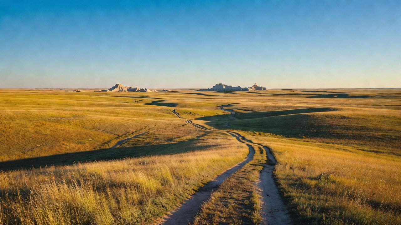
Buffalo Gap National Grassland
Where the camps cluster
The place
Buffalo Gap National Grassland is the open country you drive through to get to Badlands National Park, and most people never realize they are on it. The Forest Service describes it as stretching from Kadoka, South Dakota all the way to the tri-state border of South Dakota, Nebraska and Wyoming, and it wraps around both Badlands National Park and Minuteman Missile National Historic Site. The landscape is mixed prairie and chalky badlands -- rolling grass that suddenly drops into eroded white and banded formations, then picks back up on the far side. The USDA description of this ground from the 1960s still fits it exactly: wide expanses of gently rolling prairie grassland with rougher terrain and badland formations along the White and Cheyenne Rivers. This is not a forest and never was. Do not come here expecting shade.
Two ranger districts split it, and they sit in the same two towns the project has been run from since the 1930s: Fall River out of Hot Springs, and Wall out of Wall. The Wall office shares a building with the National Grasslands Visitor Center, which is the closest thing this place has to a front door. Between them they run one developed campground, a designated dispersed area with 70 numbered sites, two large off-highway-vehicle areas, a couple of non-motorized trails, and an enormous amount of open grassland with nothing on it at all.
What you actually need to plan around is ground conditions and grazing. This is working range -- cattle are on it May through September around Pinnacles and June through October at the Baja area, and the Forest Service asks you to close every gate behind you. The two-tracks turn to grease when they are wet; both the French Creek and Baja pages warn about mud, ruts and slick going after rain, and the honest advice is to not drive them wet at all. Storms build fast out here -- the Forest Service's own warning for the Pinnacles area names severe thunderstorms, rain, hail and strong winds arriving with little notice -- and there is nowhere to hide from any of it. The badlands formations themselves are a hazard the agency states plainly: breathtaking but unstable, sediments that crumble easily and lead to falls and injuries. Get the Motor Vehicle Use Map before you go; it shows which roads, trails and riding areas are actually open and carries the rules with it. And bring water. The developed campground does not have any.
History
The name comes from the town, and the town came from a gap -- Buffalo Gap, South Dakota, sits west of the grassland at a gap that sheltered buffalo herds in earlier times. The settlement was established in 1877 and by 1885 it was a railroad town, a spur of the Fremont, Elkhorn and Missouri Valley line. Then it burned, never fully recovered, and settled back down to a couple hundred people. Boom, bust, and a lot of empty ground afterward: that is the story of this whole landscape in miniature.
The grassland exists because of a much larger version of the same failure, and the government's own account of it is unusually blunt. The Forest Service says the Homestead Act of 1862 drew roughly six million settlers onto the plains to turn grassland into cropland, and that land which should never have been plowed yielded its topsoil to incessant dry winds. The dust storms that followed threw clouds more than 20,000 feet into the air.
We know exactly what that looked like here, because the USDA studied this specific ground before it bought it. Buffalo Gap was organized out of the Badlands-Fall River Land Utilization Project, South Dakota project number 1, and work began in 1934 with headquarters at Hot Springs and Wall. At the time of purchase 86 percent of the land was pasture, 13 percent cropland and 1 percent wasteland. The cropland sat on reasonably good clay soil, but there was not enough rain: grain yields ran 2 to 4 bushels an acre. Farms averaged 245 acres, which the department flatly called too small for economic crop production under semiarid conditions. The rangeland was badly overgrazed, with too little vegetation left to slow the spring rains or blunt the wind, so wind and water erosion did great damage. Of 706 families studied, 412 were dependent on relief. The report records inadequate housing, lack of medical care, scarcity of drinking water and food, children suffering from undernourishment and ill health, 76 little country schools averaging fewer than seven pupils each, and a high rate of tax delinquency. Three hundred thirty-seven families were living inside the project area in 1934-35. Nearly all of them moved out, and 120 needed help to do it.
It is worth being clear that this was a buyout and not a seizure. The USDA states that from the beginning of the program land acquisition was based on voluntary sales, and that condemnation was used only where it was necessary to clear title. The legal machinery ran through the emergency relief and industrial recovery acts of 1933 and 1935 and then the Bankhead-Jones Farm Tenant Act of 1937, and the paperwork moved between agencies more than once -- the Resettlement Administration, then the Farm Security Administration, then the Bureau of Agricultural Economics, then the Soil Conservation Service from October 1938, and finally the Forest Service, effective January 1954. In 1960 a Secretary of Agriculture regulation designated these land utilization grazing lands as National Grasslands and made them part of the National Forest System. Today that system holds 20 grasslands and close to four million acres, from North Dakota to Texas east of the Rockies plus three more in the Great Basin states. Buffalo Gap is the second largest of them, behind only the Little Missouri in North Dakota.
Then they fixed it, and the record of how is very specific. The grass cover was restored between 1935 and 1941 and the country was put back to grazing under control. Crews installed erosion control, planted grass, built dams and check dams to hold water and water stock, developed springs, and put in fences and cattle guards. Two game sanctuaries were established to protect wildlife. In the 54 weeks before January 1, 1937, an average of 269 men were working here every week. The land has been run ever since in cooperation with local grazing associations, which is why the map is a checkerboard of federal and private parcels and why you will be sharing it with cattle.
One line in that restoration list has aged badly: the work also included eradicating harmful rodents. On the northern plains that meant poisoning prairie dogs -- and the black-footed ferret eats almost nothing else and lives in nobody else's burrows. The same agency now runs the most successful ferret recovery program in the country on this ground. Both facts are in the federal record, about 90 years apart.
There has been one serious attempt to lock part of the grassland up permanently. In 2010 Senator Tim Johnson introduced the Tony Dean Cheyenne River Valley Conservation Act, which would have designated more than 48,000 acres as protected wilderness. It did not take. The Forest Service still describes those remote corners as recommended for wilderness, not designated as it.
Wildlife & plants
The headline animal here is one that was declared gone. The black-footed ferret is a prairie-dog specialist -- it eats them and lives in their burrows -- and when the prairie dog towns went, the ferrets went with them. Everyone thought the species was extinct. Then in 1981 a ranch dog named Shep killed one and carried it home to its owner near Meeteetse, Wyoming, about 420 miles from the Badlands, and the entire recovery program grew out of that one dead animal. Buffalo Gap became the place it worked. The Forest Service says this grassland holds the most genetically diverse population of endangered black-footed ferrets in the country, and that by late fall of 2023 the Conata Basin and Badlands National Park population had risen to about 160 animals -- roughly half of the entire wild population of the species on Earth at that point.
That number is hard-won and fragile, and the reason is a disease. Sylvatic plague sweeps through prairie dog colonies and takes the ferrets' food supply -- and the ferrets -- with it. The pre-plague count at Conata Basin was around 355 ferrets in 2007; by 2013 it was down to about 49. The response is as unglamorous as conservation gets: biologists dust prairie dog burrows with DeltaDust, an insecticide whose active ingredient is deltamethrin, to kill the fleas that carry the plague. The Forest Service biologist who runs it calls this the greatest collaboration of partnerships of any wildlife recovery effort. The work has gotten stranger and more hopeful lately -- the U.S. Fish and Wildlife Service announced the birth of two cloned ferrets, Noreen and Antonia, following an earlier clone, Elizabeth Ann, who is now an adult.
You are unlikely to see a ferret; they are nocturnal and rare. You will see what supports them. Prairie dog colonies are common enough that the Forest Service tells you to keep dogs leashed or under voice control around them at the Baja area. Bighorn sheep, in the agency's words, visit the Pinnacles area often. The USDA's own 1960s wildlife inventory for this project counted roughly 1,600 antelope, 720 mule deer and 83 white-tailed deer, along with numerous small game animals and game birds including wild turkeys -- a useful snapshot of what this country supports when the grass is working.
The bird worth planning a trip around is the grouse. Each spring the Wall Ranger District sets up one to two viewing blinds on display grounds -- leks -- where sharp-tailed grouse or prairie chickens dance and boom for the females. One site is set up for sharp-tailed grouse roughly 6.5 miles from Interstate 90 Exit 110 near Wall; the other, for prairie chickens, is reached from Exit 131. The blinds have small square windows to watch and photograph through, they are first come first served with no reservation required, and the rule that matters is that you must be inside at least 45 minutes before sunrise or you will break up the lek. Plan on about a four-hour outing, most of it in the dark and cold, and get the information packet with directions and sunrise times from the Wall Ranger District first.
Notable features
Start at the National Grasslands Visitor Center at 708 Main Street in Wall -- two blocks south of Wall Drug, right off Exit 110 on I-90, and always free. It is not just a Buffalo Gap visitor center; it is the interpretive front door for all 20 national grasslands and the Midewin National Tallgrass Prairie. Inside are exhibits on grassland wildlife, plants, grazing management and the history of the Great Plains, a Living Landscape native plant garden outside, and a fossil wall completed in June 2025 that lays out the geologic layers of the local badlands formations with replicated fossils in place. The film is called Ferret Town and runs in a 10-minute or a 28-minute version. Hours are Monday through Thursday, 8 a.m. to 4:30 p.m. Mountain Time.
For camping, the Pinnacles Dispersed Camping Area is the one most people want: 6 miles south of Wall near the park's Pinnacles Entrance, reached off Highway 240 and Forest System Roads 7158 and 7170, with 70 designated sites marked by wooden posts, first come first served, no fee, and a 14-day stay limit that applies year-round. It is prairie-edge badlands camping with the national park right there, which is exactly why it fills. The grassland's one developed campground is French Creek, 11.4 miles east of Fairburn -- picnic tables, fire rings, vault toilets, hitching posts for stock, a mowed area beside the gravel lot for RVs and trailers, no fee and no potable water. Its real draw is what is next to it: access to the Fairburn Agate Beds. The Forest Service calls the agates found on Buffalo Gap and Oglala rare and precious, and maps five rockhounding locations on this grassland. The collecting rules are real -- surface collection only, 25 pounds per day and 250 pounds per year, nothing collected for commercial purposes, and no vertebrate fossils or their tracks without a permit, which is issued only for scientific research and education. Common invertebrate fossils may be taken for personal use.
This is genuinely good OHV country, and the Forest Service treats it as a destination. Railroad Buttes, on the Fall River District, has miles of trail plus three open-riding areas totaling 1,745 acres -- North with its parking lot and hill climb, West, and East. There is a big gravel lot with a vault toilet, dispersed camping is allowed, there is no potable water, and note that fireworks and shooting are prohibited, with a shooting closure area in the middle of the travel management area. From Rapid City the approach is east on Highway 44 about 21 miles, then south on 160th Avenue 3.5 miles. The Baja OHV Travel Management Area on the Wall District is a different animal -- roughly 1,335 acres open to cross-country motorized travel over smooth rock-covered hills and badlands formations, about 7.2 miles from Interior off Highway 44. Camping, hiking, 4x4 and rockhounding are all welcome there, the Conata Basin trail system connects to the north, and outside the Baja boundary you are back on designated trails only.
On foot or horseback, the grassland is thin on built trail and heavy on open country. Saddle Pass Horse Trail is one of the two designated non-motorized trails; the Prairie Bike Path is a two-loop mountain bike route. Beyond that you are looking at remote natural areas the Forest Service describes as recommended for wilderness, sitting as a quiet backdrop to the far busier Badlands National Park and Black Hills National Forest -- which is the argument for coming here in the first place. Dispersed camping is allowed across the grassland for a maximum of 14 nonconsecutive days in any 30-day period; camp 100 feet away from any creek or stream and a half mile from developed recreation sites including campgrounds and picnic areas, keep vehicles within 300 feet of a road shown on the Motor Vehicle Use Map, and understand that you are held responsible for any wildfire your campfire starts.
Camps are sourced from public U.S. Forest Service recreation data and have not been personally visited. Roads shown are Forest Service passenger-car routes (maintenance level 3–5) and may be seasonal or gated. Always confirm access, fees and fire rules with the ranger district before you go. Found a fee where we show free? Tell us on the contact page.