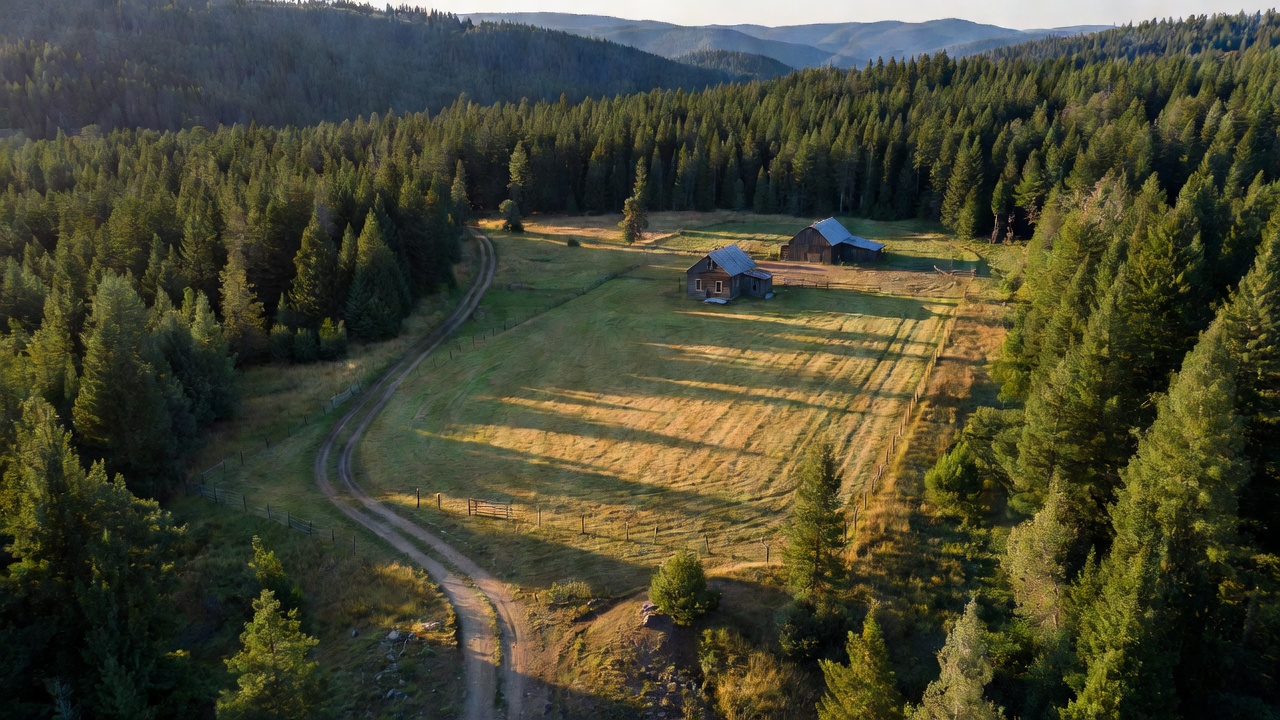
Inholding
An inholding is private land sitting inside the boundary of a national forest, park or other public unit -- the map is green on all four sides of it, the deed belongs to somebody who is not you, and camping there is trespassing no matter how wild and unmarked it looks.
In the field
Wikipedia gives the plain version: an inholding is "privately owned land inside the boundary of a national park, national forest, state park, or similar publicly owned, protected area." They exist because the government was giving land away long before it started holding onto any -- all of the federal land-management agencies "were formed over a century after the government sold and issued land grants to private citizens." By the time somebody drew a forest or park boundary, the line went around ground that already had owners, many of whom had held it for generations and were not selling. The Forest Service keeps honest books about it: in its annual Land Areas Report, "Other Acreage" means "Areas within National Forest System boundaries that are not federally owned or administered by the Forest Service," and "Gross Acreage" is "The sum of National Forest System and other acres." The gap between those two numbers is every inholding in the country. The Park Service counts the same way and reports "more than 2.6 million acres of privately owned lands remain within park boundaries" of a system "more than 85 million acres" in size -- and says outright that buying it all is "not always necessary and, in some cases, not feasible." Inholdings are not a backlog. They are a permanent feature.
For your trip the consequence is narrow and absolute: your right to camp follows ownership, not color. The polite inholdings announce themselves -- a mown hay meadow with a fence line and a barn, the kind of hard-edged rectangle punched into the timber that you can pick out from a satellite view. The ones that get people are the other kind: forty acres of second-growth indistinguishable from the public forest around it, no fence, nothing posted, with a two-track running in that looks exactly like every dispersed spur you have ever camped on. Aerial imagery shows you trees. It does not show you a deed. The layer that actually answers the question is the Forest Visitor Map for that specific forest, which the Forest Service says carries "roads, forest boundaries and public/private land distinctions" -- ownership shading that a generic phone basemap almost never has. The forests say it without decoration; the Helena-Lewis and Clark National Forest's dispersed camping page simply tells you to "respect private landowners and refrain from camping and trespassing on private lands."
Here is the catch, and it is the one that fools careful people: the road is not evidence. An inholding owner has a legal path to their own land across public ground. 36 CFR Part 251, Subpart D lays out "the procedures by which landowners may apply for access across National Forest System lands," and defines adequate access as "a route and method of access to non-Federal land that provides for reasonable use and enjoyment of the non-Federal land consistent with similarly situated non-Federal land and that minimizes damage or disturbance to National Forest System lands and resources." So a graded, well-kept road through national forest can exist for exactly one reason: getting a rancher to their hay. Nothing about a road being drivable makes its destination public. And the right does not run both ways -- there is no general public right to cross an inholding to reach the public land behind it. That is how ground gets landlocked. The BLM's own count found 1.8 million acres of landlocked, inaccessible federally managed land in Montana and the Dakotas alone, against 8.3 million BLM-managed acres in those three states, and the remedy is slow and legalistic: it digitized 378 legally perfected easement deeds and patent reservations, opening over 2.8 million acres.
The official map also hedges, and you should read the hedge. The Forest Service's visitor-map disclaimer says the map and its data are "not intended to be used to determine title, ownership, legal boundaries, legal jurisdiction," that the agency "makes no warranty, express or implied," and then tells you flatly to "Obtain permission before entering private lands, and check with appropriate government offices for restrictions that may apply to public lands." Translation: the ownership line on the map is a strong hint, not a ruling, and the burden is yours. Trespass is state law, and the details -- including whether land has to be posted before you can be cited -- vary from state to state, so "it wasn't marked" is not a defense worth planning a trip around. When a spot is ambiguous, the district office is a phone call. And note that even once you are certainly on public ground the rules stay local: Mt. Hood allows camping "in a single location on the Forest for only up to 14 consecutive days at a time and camp in any location on the Forest for no more than 28 days total during a calendar year," while the Apache-Sitgreaves gives you "no more than 14 days in a 30-day period" and then makes you "move off of the Forest for at least 16 days." Same shade of green, different rulebook -- and neither rulebook covers the forty acres in the middle that the agency doesn't own.
Worth keeping in proportion, too: private forest is the normal case in this country, not the exception. The Forest Service notes that "more than half the forest land in the United States is owned and managed by some 10.6 million private forest owners." An inholding is just that ordinary private ownership in an unusually confusing place -- with public land on every side of it and no line on the ground to tell you which is which.
See also
Put it to use
Sources
- Wikipedia -- Inholding
- U.S. Forest Service -- Land Areas Report, Definition of Terms
- National Park Service -- Land and Water Conservation Fund, Federal Land Acquisition
- 36 CFR Part 251, Subpart D -- Access to Non-Federal Lands
- U.S. Forest Service -- About the Forest Service Visitor Map (data disclaimer)
- U.S. Forest Service -- Maps (Forest Visitor Maps, MVUMs)
- U.S. Forest Service -- Helena-Lewis and Clark National Forest, Dispersed Camping
- U.S. Forest Service -- Mt. Hood National Forest, Dispersed Camping
- U.S. Forest Service -- Apache-Sitgreaves National Forests, Dispersed Camping Guidelines
- Bureau of Land Management -- Montana/Dakotas access pilot project (landlocked lands, easements)
- U.S. Forest Service -- Private Land